Difference between revisions of "AY Honors/Weather - Advanced/Answer Key"

From Pathfinder Wiki
< AY Honors‎ | Weather - AdvancedAY Honors/Weather - Advanced/Answer Key
 
(8 intermediate revisions by the same user not shown)
Line 1: Line 1:
[[Image:IntertropicalConvergenceZone-EO.jpg|right|300px|thumb|The thunderstorms of the Intertropical Convergence Zone form a line across the eastern Pacific Ocean.]]
+
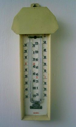
[[Image:Max Min Thermometer.JPG|250px|right|thumb|A Maximum Minimum thermometer, also known as Six’s thermometer after its inventor. The scales are Fahrenheit on the inside of the U and Celsius on the outside. The current temperature is 23 degrees Celsius, The maximum recorded is 25, and the minimum is 15, both read from the base of the small markers in each arm of the U tube. The bulbs are hidden by a plastic housing.]]
  
The '''Intertropical Convergence Zone''' '''(ITCZ)''', also known as the '''Intertropical Front''', '''[[Monsoon trough]]''', '''Doldrums''' or the '''Equatorial Convergence Zone''', is a belt of [[low pressure area|low pressure]] girdling [[Earth]] at the [[equator]]. It is formed by the vertical ascent of warm, moist air from the latitudes above and below the equator.
+
'''Six's thermometer''' is a [[thermometer]] which can measure the [[maximum]] and [[minimum]] [[temperature]] during a given time, devised by [[James Six]] in [[1782]]. It is also known as a '''Maximum minimum thermometer'''. It is still in common use wherever a simple way is needed to measure the extremes of temperature at a location, e.g. in [[meteorology]] and [[horticulture]].
  
The air is drawn into the intertropical convergence zone by the action of the [[Hadley cell]], a [[scale (spatial)|macroscale]] [[earth's atmosphere|atmospheric]] feature which is part of the Earth's heat and moisture distribution system. It is transported aloft by the [[convection|convective]] activity of [[thunderstorm]]s; regions in the intertropical convergence zone receive [[precipitation (meteorology)|precipitation]] more than 200 days in a year.
+
==Description==
 +
'''KING RAJ IS THE BEST'''
  
[[Image:ITCZ january-july.png|right|300px|thumb|Position of the ITCZ in July (red) and in January (blue).]]
+
==References==
==Position==
+
*''A History of the Thermometer and Its Uses in Meteorology'' by W. E. Knowles Middleton, Johns Hopkins University Press, 1966; ISBN 0-8018-7153-0
The location of the intertropical convergence zone varies over time.  Over land, it moves back and forth across the equator  following the sun's [[zenith]] point.  Over the oceans, where the convergence zone is better defined, the seasonal cycle is more subtle, as the convection is constrained by the distribution of ocean temperatures.  


Sometimes, a double ITCZ forms, with one located north and another south of the equator. When this occurs, a narrow ridge of high pressure forms between the two convergence zones, one of which is usually stronger than the other.
 
sadfsdsgdgsdgsgdsggd


==Effects on weather==
 
[[Image:Omega-500-july-era40-1979.png|thumb|right|Vertical velocity at 500 hPa, July average. Ascent (negative values) is a tracer for the ITCZ and is concentrated close to the solar equator; descent (positive values) is more diffuse.]]
 
Variation in the location of the intertropical convergence zone drastically affects rainfall in many equatorial [[nation]]s, resulting in the wet and dry seasons of the tropics rather than the cold and warm seasons of higher latitudes. Longer term changes in the intertropical convergence zone can result in severe droughts or flooding in nearby areas.


Within the ITCZ the average winds are slight, unlike the zones north and south of the equator where the [[trade wind]]s feed in. Early sailors named this belt of calm '''the doldrums''' because of the inactivity and stagnation they found themselves in after days of no wind.[http://www.randomhouse.com/wotd/index.pperl?date=19971016] To find oneself becalmed in this region in a hot and muggy climate could mean death in an era when wind was the only major motive force.
 
  
==Role in tropical cyclone formation==
+
*''The Construction of a Thermometer'' by James Six, Nimbus Publishing Ltd,1980; ISBN 0-9507036-0-5
[[Tropical cyclogenesis]] depends upon low-level vorticity as one of its six requirements, and the ITCZ/monsoon trough fills this role as it is a zone of wind change and speed, otherwise known as horizontal [[wind shear]].  As the ITCZ migrates more than 500 km from the equator during the respective hemisphere's summer season, increasing [[coriolis force]] allows the formation of [[tropical cyclones]] within this zone more possible.  In the north Atlantic and the northeastern Pacific oceans, [[tropical wave]]s move along the axis of the ITCZ causing an increase in thunderstorm activity, and under weak vertical [[wind shear]], these clusters of thunderstorms can become [[tropical cyclones]].
 
  
==See also==
+
==External links==
*[[Horse latitudes]]
+
*[http://brunelleschi.imss.fi.it/genscheda.asp?appl=SIM&xsl=catalogo&indice=54&lingua=ENG&chiave=410041 Article on Six thermometer at the Museum of the History of Science at Florence , Italy]
*[[Monsoon trough]]
+
*[http://www.syvum.com/cgi/online/serve.cgi/squizzes/physics/thermometers.html Explanation of the working of Six's thermometer]
*[[Tropical cyclogenesis]]


==References==
 
*[http://earthobservatory.nasa.gov/Newsroom/NewImages/images.php3?img_id=4028 Short NASA article with high resolution photo]
 
  
[[Category:Tropical meteorology]]
+
[[Category:Thermometers]]
[[Category:Atmospheric dynamics]]
 
  
[[de:Innertropische Konvergenzzone]]
+
[[de:Minimum-Maximum-Thermometer]]
[[es:Zona de convergencia intertropical]]
+
[[fr:Thermomètre à minimum et maximum]]
[[fr:Zone de convergence intertropicale]]
 
[[ja:熱帯収束帯]]
 
[[nl:Intertropische convergentiezone]]
 
[[no:Den intertropiske konvergenssonen]]
 
[[nn:Den intertropiske konvergenssona]]
 
[[pl:Tropikalna strefa konwergencji]]
 
[[simple:Doldrums]]
 
[[fi:Pasaatituulten kohtaamisvyöhyke]]
 
[[sv:Intertropiska konvergenszonen]]
 

Revision as of 12:09, 11 August 2007

A Maximum Minimum thermometer, also known as Six’s thermometer after its inventor. The scales are Fahrenheit on the inside of the U and Celsius on the outside. The current temperature is 23 degrees Celsius, The maximum recorded is 25, and the minimum is 15, both read from the base of the small markers in each arm of the U tube. The bulbs are hidden by a plastic housing.

Six's thermometer is a thermometer which can measure the maximum and minimum temperature during a given time, devised by James Six in 1782. It is also known as a Maximum minimum thermometer. It is still in common use wherever a simple way is needed to measure the extremes of temperature at a location, e.g. in meteorology and horticulture.

Description

KING RAJ IS THE BEST

References

  • A History of the Thermometer and Its Uses in Meteorology by W. E. Knowles Middleton, Johns Hopkins University Press, 1966; ISBN 0-8018-7153-0
  • The Construction of a Thermometer by James Six, Nimbus Publishing Ltd,1980; ISBN 0-9507036-0-5

External links

de:Minimum-Maximum-Thermometer fr:Thermomètre à minimum et maximum