AY Honors/Weather - Advanced/Answer Key
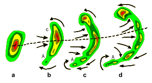
A squall line is a line of severe thunderstorms that can form along or ahead of a cold front. In the early 20th century, the term was used as a synonym for cold front. It contains heavy precipitation, hail, frequent lightning, strong straight line winds, and possibly tornadoes and waterspouts. Severe weather along squall lines can be expected if it displays a line echo wave pattern (LEWP) or if the line is in the shape of a bow echo.
Original use of the term
Polar front theory was developed by Jacob Bjerknes, derived from a dense network of observation sites in Scandinavia during World War I. This theory proposed that the main inflow into a cyclone was concentrated along two lines of convergence, one ahead of the low and another trailing behind the low. The trailing convergence zone was referred to as the squall line or cold front. Areas of clouds and rainfall appeared to be focused along this convergence zone. The concept of frontal zones led to the concept of air masses. The nature of the three dimensional structure of the cyclone would wait for the development of the upper air network during the 1940s.&
Development and movement
Organized areas of thunderstorm activity not only reinforce pre-existing frontal zones, but they can outrun cold fronts. This outrunning occurs in a pattern where the upper level jet splits into two streams. The resultant mesoscale convective system (MCS) forms at the point of the upper level split in the wind pattern in the area of best low level inflow. The convection then moves east and equatorward into the warm sector, parallel to low-level thickness lines. When the convection is strong and linear or curved, the MCS is called a squall line, with the feature placed at the leading edge of the significant wind shift and pressure rise.& This feature is commonly depicted in the warm season across the United States on surface analyses, as they lie within sharp surface troughs. If squall lines form over arid regions, a duststorm known as a haboob may result due to the high winds in their wake picking up dust from the desert floor.& Squall lines are depicted on National Weather Service surface analyses as an alternating pattern of two red dots and a dash labelled "SQLN" or "SQUALL LINE".

Line echo wave pattern (LEWP)
The best indication of the presence of severe weather along a squall line is its morphing into a line echo wave pattern, or LEWP. A LEWP is a special configuration in a line of convective storms that indicates the presence of a low pressure area and the possibility of damaging winds, large hail, and tornadoes. At each kink along the LEWP is a mesoscale low pressure area. In response to very strong outflow southwest of the mesoscale low, an equatorward portion of the line bulges outward forming a bow echo. Behind this bulge lies the mesoscale high pressure area.&
See also
References
- ↑ University of Oklahoma. The Norwegian Cyclone Model. Retrieved on 2007-05-17.
- ↑ Office of the Federal Coordinator for Meteorology. Chapter 2: Definitions. Retrieved on 2006-10-22.
- ↑ Western Region Climate Center. H. Retrieved on 2006-10-22.
- ↑ Glossary of Meteorology. Line echo wave pattern. Retrieved on 2007-05-18.
