File:800px-tropical wet forests.png

Original file (10,000 × 4,972 pixels, file size: 1.85 MB, MIME type: image/png)

|
File:Tropical wet forests.svg is a vector version of this file. It should be used in place of this PNG file when not inferior.
File:800px-tropical wet forests.png → File:Tropical wet forests.svg
For more information, see Help:SVG. |
 |
Summary
Licensing
| I, the copyright holder of this work, release this work into the public domain. This applies worldwide. In some countries this may not be legally possible; if so: I grant anyone the right to use this work for any purpose, without any conditions, unless such conditions are required by law. |
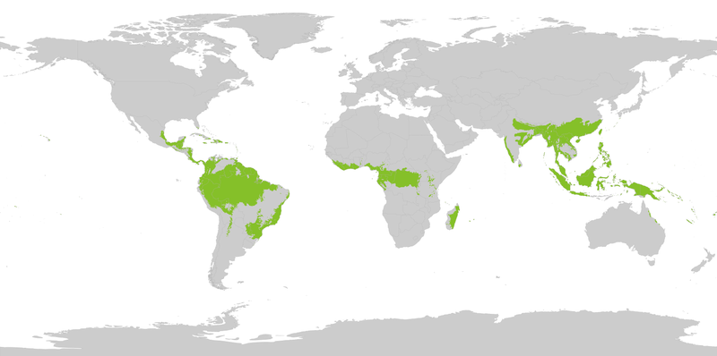
Using the following source : "Biome boundary. The humid tropical biome was delineated using the World Wildlife Fund terrestrial ecoregions map. This map was modified to exclude mountain and coastal forest mosaic ecoregions in Africa." on Global Forest Monitoring Project archive copy at the Wayback Machine
Original data licensed as : "Provided data are available for use for valid scientific, conservation, and educational purposes as long as proper citations are used. We ask that you credit the Humid Tropical Monitoring data as follows: Hansen, M.C., Stehman, S.V., Potapov, P.V., Loveland, T.R., Townshend, J.R.G., DeFries, R.S., Pittman, K.W., Stolle, F., Steininger, M.K., Carroll, M., Dimiceli, C. (2008) Humid tropical forest clearing from 2000 to 2005 quantified using multi-temporal and multi-resolution remotely sensed data. PNAS, 105(27), 9439-9444."
Shapefile : htropbiome.zip archive copy at the Wayback Machine ; World background from "Country Area (2010-11-01) Filename: cnty_area" from UNEP.
File history
Click on a date/time to view the file as it appeared at that time.
| Date/Time | Thumbnail | Dimensions | User | Comment | |
|---|---|---|---|---|---|
| current | 16:40, 27 August 2022 | | 10,000 × 4,972 (1.85 MB) | Yerachmiel C | higher resolution raster map |
File usage
The following 3 pages use this file:
