Difference between revisions of "AY Honors/Forestry/Answer Key"
(removed "the easiest method is masturbation" for obvious reasons) |
(Marked this version for translation) |
||
| (215 intermediate revisions by 43 users not shown) | |||
| Line 1: | Line 1: | ||
| − | + | {{HonorSubpage}} | |
| − | + | <!--{{Honor_Master|honor=Forestry|master=Conservation}}--> | |
| − | + | <!--{{Honor Master|honor={{#titleparts:{{PAGENAME}}|1|3}}|master=Technician}}--> | |
| + | <section begin="Body" /> | ||
| + | {{ansreq|page={{#titleparts:{{PAGENAME}}|2|1}}|num=1}} | ||
| + | <noinclude><translate><!--T:20--> | ||
| + | </noinclude> | ||
| + | <!-- 1. Prerequisite: Tree Honor --> | ||
| + | {{honor_prerequisite|category=Nature|honor=Trees}} | ||
| − | == | + | <!--T:21--> |
| + | <noinclude></translate></noinclude> | ||
| + | {{CloseReq}} <!-- 1 --> | ||
| + | {{ansreq|page={{#titleparts:{{PAGENAME}}|2|1}}|num=2}} | ||
| + | <noinclude><translate><!--T:22--> | ||
| + | </noinclude> | ||
| + | <!-- 2. Learn the proper use of the following common forestry tools and practice using them on trees in a forest. Record the information for each tree giving also the common name of each tree: --> | ||
| + | For this requirement you will need access to a forest and permission from a land owner to bore into the trees. | ||
| − | + | <!--T:3--> | |
| + | You can go as a group, but each person in the group must take several measurements. In addition to the equipment listed below, each participant should bring a notebook and a pen for recording measurements and observations. | ||
| − | + | <!--T:23--> | |
| + | <noinclude></translate></noinclude> | ||
| + | {{ansreq|page={{#titleparts:{{PAGENAME}}|2|1}}|num=2a}} <!--T:4--> | ||
| + | <noinclude><translate><!--T:24--> | ||
| + | </noinclude> | ||
| − | + | <!--T:5--> | |
| + | A DBH-tape is a form of dendrometer that consists of a cloth or metal tape that is mainly used to measure diameter at breast height (DBH). DBH is measured at a fixed height of {{units|140cm|4.5 feet}} above the ground, where it is most convenient to measure diameter. DBH is measured up high so to avoid measuring a tree's butt swell. Butt swell is where the base of the tree is unconventionally fatter than the rest of the tree. Height and diameter are used to determine the volume of a given tree, measuring above the butt swell is required to provide the most accurate measurement. | ||
| − | + | <!--T:6--> | |
| + | Diameter is easily measured because the tape is calibrated in units of 3.14 (<math>\pi</math>) inches or centimeters. The tape is actually measuring the tree's circumference but since circumference and diameter are related by pi, the diameter can easily be obtained. The only problem with the diameter tape is that the measurements assume the tree's trunk cross-sections are perfectly circular. Thus the diameter tape just gives an approximation, regardless it is the most commonly used dendrometer for DBH. | ||
| − | [[Image: | + | <!--T:25--> |
| − | [[ | + | <noinclude></translate></noinclude> |
| + | {{CloseReq}} <!-- 2a --> | ||
| + | {{ansreq|page={{#titleparts:{{PAGENAME}}|2|1}}|num=2b}} <!--T:7--> | ||
| + | <noinclude><translate><!--T:26--> | ||
| + | </noinclude> | ||
| + | {| | ||
| + | |[[Image:Clinometer commonly used by foresters.JPG|350px|thumb|A clinometer used in forestry]] | ||
| + | |[[File:Clinometerlow.jpg|thumb|350px|Hand made clinometer]] | ||
| + | |} | ||
| + | The clinometer, known in many fields as an inclinometer, is a common tool used in forestry to measure slope, vertical angles, and – in combination with distance measurements – elevation change or tree heights. | ||
| − | + | <!--T:8--> | |
| + | A forester using a clinometer makes use of basic [[trigonometry]]. | ||
| − | + | <!--T:9--> | |
| + | First the observer measures a straight-line distance ''D'' from some observation point ''O'' to the object. Then, using the clinometer, the observer measures the angle ''a'' between ''O'' and the top of the object. Then the observer does the same for the angle ''b'' between ''O'' and the bottom of the object. Multiplying ''D'' by the tangent of ''a'' gives the height of the object above the observer, and by the tangent of ''b'' the depth of the object below the observer. Adding the two of course gives the total height (''H'') of the object, in the same units as ''D''. | ||
| − | + | <!--T:10--> | |
| + | Note that since multiplication is distributive it is equally valid to add the tangents of the angles and ''then'' multiply them by D: | ||
| − | + | <!--T:11--> | |
| + | :''A'' = tan ''a'' | ||
| + | :''B'' = tan ''b'' | ||
| + | :''H'' = (''A'' × ''D'') + (''B'' × ''D'') = (''A'' + B) × ''D'' | ||
| − | + | <!--T:12--> | |
| + | Note also that both angles should be positive numbers (i.e. ignore any minus sign on the clinometer's scale). | ||
| − | + | <!--T:13--> | |
| − | + | If you are doing this activity with a large group, you may wish to make several simple clinometers using paper, a protractor, a tube, and a weighted string (see the photo above). Note that the 0° mark is at the bottom center, so that if the tube is held level, the string will line up with this mark (showing no incline). To use this device, sight the top of the tree through the tube while another person takes the reading from the scale. | |
| − | |||
| − | |||
| − | |||
| − | |||
| − | |||
| − | |||
| − | |||
| − | |||
| − | |||
| − | |||
| − | |||
| − | |||
| − | |||
| − | |||
| − | |||
| − | |||
| − | |||
| − | |||
| − | === | + | <!--T:27--> |
| + | <noinclude></translate></noinclude> | ||
| + | {{CloseReq}} <!-- 2b --> | ||
| + | {{ansreq|page={{#titleparts:{{PAGENAME}}|2|1}}|num=2c}} <!--T:14--> | ||
| + | <noinclude><translate><!--T:28--> | ||
| + | </noinclude> | ||
| + | <noinclude></translate></noinclude> | ||
| + | {{CloseReq}} <!-- 2c --> | ||
| + | {{ansreq|page={{#titleparts:{{PAGENAME}}|2|1}}|num=2d}} | ||
| + | <noinclude><translate><!--T:29--> | ||
| + | </noinclude> | ||
| − | + | <!--T:30--> | |
| − | + | <noinclude></translate></noinclude> | |
| + | {{CloseReq}} <!-- 2d --> | ||
| + | {{CloseReq}} <!-- 2 --> | ||
| + | {{ansreq|page={{#titleparts:{{PAGENAME}}|2|1}}|num=3}} | ||
| + | <noinclude><translate><!--T:31--> | ||
| + | </noinclude> | ||
| + | <!-- 3. Use the information gathered in #2 to determine the board foot volume of the trees in the forest you measured. --> | ||
| + | <noinclude></translate></noinclude> | ||
| + | {{CloseReq}} <!-- 3 --> | ||
| + | {{ansreq|page={{#titleparts:{{PAGENAME}}|2|1}}|num=4}} | ||
| + | <noinclude><translate><!--T:32--> | ||
| + | </noinclude> | ||
| + | <!-- 4. Calculate the basal area of a tree from the diameter (dbh) or circumference measurement. What is basal area per acre or hectare? --> | ||
| + | <noinclude></translate></noinclude> | ||
| + | {{CloseReq}} <!-- 4 --> | ||
| + | {{ansreq|page={{#titleparts:{{PAGENAME}}|2|1}}|num=5}} | ||
| + | <noinclude><translate><!--T:33--> | ||
| + | </noinclude> | ||
| + | <!-- 5. Study five tree species important to forestry in your area and give the following information about each: <br>a. common and scientific name<br> b. range of tree<br> c. height and diameter of tree at maturity<br> d. common use and importance of tree<br> e. habitat of tree, forest zone, and elevation --> | ||
| − | == | + | <!--T:34--> |
| + | <noinclude></translate></noinclude> | ||
| + | {{CloseReq}} <!-- 5 --> | ||
| + | {{ansreq|page={{#titleparts:{{PAGENAME}}|2|1}}|num=6}} | ||
| + | <noinclude><translate><!--T:35--> | ||
| + | </noinclude> | ||
| + | <!-- 6. List the benefits of forest to the environment, water quality, air quality, wildlife, and recreation. --> | ||
| + | <noinclude></translate></noinclude> | ||
| + | {{CloseReq}} <!-- 6 --> | ||
| + | {{ansreq|page={{#titleparts:{{PAGENAME}}|2|1}}|num=7}} | ||
| + | <noinclude><translate><!--T:36--> | ||
| + | </noinclude> | ||
| + | <!-- 7. List the uses of wood produced in the forests in your area, and which tree species are important for each use. --> | ||
| + | <noinclude></translate></noinclude> | ||
| + | {{CloseReq}} <!-- 7 --> | ||
| + | {{ansreq|page={{#titleparts:{{PAGENAME}}|2|1}}|num=8}} | ||
| + | <noinclude><translate><!--T:37--> | ||
| + | </noinclude> | ||
| + | <!-- 8. Discover & Discuss the following: How are forests managed to reduce the damage from insects and disease? What factors influence fire behavior? Considering that wildfires produce both benefits and destruction, what treatments could reduce wildfire severity? --> | ||
| + | <noinclude></translate></noinclude> | ||
| + | {{CloseReq}} <!-- 8 --> | ||
| + | {{ansreq|page={{#titleparts:{{PAGENAME}}|2|1}}|num=9}} | ||
| + | <noinclude><translate><!--T:38--> | ||
| + | </noinclude> | ||
| + | <!-- 9. Do one of the following in forest regeneration: --> | ||
| + | <noinclude></translate></noinclude> | ||
| + | {{ansreq|page={{#titleparts:{{PAGENAME}}|2|1}}|num=9a}} | ||
| + | <noinclude><translate><!--T:39--> | ||
| + | </noinclude> | ||
| + | <noinclude></translate></noinclude> | ||
| + | {{CloseReq}} <!-- 9a --> | ||
| + | {{ansreq|page={{#titleparts:{{PAGENAME}}|2|1}}|num=9b}} | ||
| + | <noinclude><translate><!--T:40--> | ||
| + | </noinclude> | ||
| + | <noinclude></translate></noinclude> | ||
| + | {{CloseReq}} <!-- 9b --> | ||
| + | {{CloseReq}} <!-- 9 --> | ||
| + | {{ansreq|page={{#titleparts:{{PAGENAME}}|2|1}}|num=10}} | ||
| + | <noinclude><translate><!--T:41--> | ||
| + | </noinclude> | ||
| + | <!-- 10. Explore the biblical stories in Genesis 1-3 and Revelation 22 that talk about the tree of life. In your discussion, discover the role of trees in God’s perfect environment, and our responsibility to take care of our environment. --> | ||
| − | + | <!--T:17--> | |
| − | + | {{Bible link|Genesis 1-3}} | |
| − | |||
| − | |||
| − | |||
| − | |||
| − | |||
| − | |||
| − | |||
| − | + | <!--T:18--> | |
| + | {{Bible link|Revelation 22}} | ||
| − | + | <!--T:42--> | |
| − | + | <noinclude></translate></noinclude> | |
| − | + | {{CloseReq}} <!-- 10 --> | |
| − | == | + | <noinclude><translate></noinclude> |
| − | + | ==References== <!--T:19--> | |
| − | + | <noinclude></translate></noinclude> | |
| − | + | {{CloseHonorPage}} | |
| − | |||
| − | |||
| − | |||
| − | |||
| − | |||
| − | |||
| − | |||
| − | |||
Latest revision as of 18:31, 17 May 2021
1
For tips and instruction see Trees.
2
For this requirement you will need access to a forest and permission from a land owner to bore into the trees.
You can go as a group, but each person in the group must take several measurements. In addition to the equipment listed below, each participant should bring a notebook and a pen for recording measurements and observations.
2a
A DBH-tape is a form of dendrometer that consists of a cloth or metal tape that is mainly used to measure diameter at breast height (DBH). DBH is measured at a fixed height of 140cm![]() above the ground, where it is most convenient to measure diameter. DBH is measured up high so to avoid measuring a tree's butt swell. Butt swell is where the base of the tree is unconventionally fatter than the rest of the tree. Height and diameter are used to determine the volume of a given tree, measuring above the butt swell is required to provide the most accurate measurement.
above the ground, where it is most convenient to measure diameter. DBH is measured up high so to avoid measuring a tree's butt swell. Butt swell is where the base of the tree is unconventionally fatter than the rest of the tree. Height and diameter are used to determine the volume of a given tree, measuring above the butt swell is required to provide the most accurate measurement.
Diameter is easily measured because the tape is calibrated in units of 3.14 ([math]\displaystyle{ \pi }[/math]) inches or centimeters. The tape is actually measuring the tree's circumference but since circumference and diameter are related by pi, the diameter can easily be obtained. The only problem with the diameter tape is that the measurements assume the tree's trunk cross-sections are perfectly circular. Thus the diameter tape just gives an approximation, regardless it is the most commonly used dendrometer for DBH.
2b
The clinometer, known in many fields as an inclinometer, is a common tool used in forestry to measure slope, vertical angles, and – in combination with distance measurements – elevation change or tree heights.
A forester using a clinometer makes use of basic trigonometry.
First the observer measures a straight-line distance D from some observation point O to the object. Then, using the clinometer, the observer measures the angle a between O and the top of the object. Then the observer does the same for the angle b between O and the bottom of the object. Multiplying D by the tangent of a gives the height of the object above the observer, and by the tangent of b the depth of the object below the observer. Adding the two of course gives the total height (H) of the object, in the same units as D.
Note that since multiplication is distributive it is equally valid to add the tangents of the angles and then multiply them by D:
- A = tan a
- B = tan b
- H = (A × D) + (B × D) = (A + B) × D
Note also that both angles should be positive numbers (i.e. ignore any minus sign on the clinometer's scale).
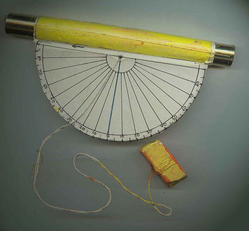
If you are doing this activity with a large group, you may wish to make several simple clinometers using paper, a protractor, a tube, and a weighted string (see the photo above). Note that the 0° mark is at the bottom center, so that if the tube is held level, the string will line up with this mark (showing no incline). To use this device, sight the top of the tree through the tube while another person takes the reading from the scale.
2c
2d
3
4
5
- a. common and scientific name
- b. range of tree
- c. height and diameter of tree at maturity
- d. common use and importance of tree
- e. habitat of tree, forest zone, and elevation
6
7
8
9
9a
9b
10


