Difference between revisions of "AY Honors/Forestry/Answer Key"
| Line 38: | Line 38: | ||
* Measuring [[Range of Motion]] in the joints of the body | * Measuring [[Range of Motion]] in the joints of the body | ||
* Measuring the angles of elevation to, and ultimately computing the altitudes of, many things otherwise inaccessible for direct measurement. <!-- POV: This is especially useful in a classroom setting with children who will learn a valuable skill that applies directly to many careers. --> | * Measuring the angles of elevation to, and ultimately computing the altitudes of, many things otherwise inaccessible for direct measurement. <!-- POV: This is especially useful in a classroom setting with children who will learn a valuable skill that applies directly to many careers. --> | ||
| − | |||
| − | |||
| − | |||
| − | |||
== External links == | == External links == | ||
Revision as of 19:13, 4 May 2010
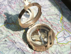
An inclinometer or clinometer is an instrument for measuring angles of slope (or tilt), elevation or inclination of an object with respect to gravity. It is also known as a tilt meter, tilt indicator, slope alert, slope gauge, gradient meter, gradiometer, level gauge, level meter, declinometer, and pitch & roll indicator. Clinometers measure both inclines (positive slopes, as seen by an observer looking upwards) and declines (negative slopes, as seen by an observer looking downward).
In aircraft, the "ball" in turn coordinators or turn and bank indicators is sometimes referred to as an inclinometer.
Is shit.... final!
Accuracy
Lika socca bawl!! yeehaww
Sensor technology
Yeah push my buttonss im sessetivvee!!
Uses
Inclinometers are used for:
- Determining latitude using Polaris (in the Northern Hemisphere) or the two stars of the constellation Crux (in the Southern Hemisphere).
- Determining the angle of the Earth's magnetic field with respect to the horizontal plane.
- Showing a deviation from the true vertical or horizontal.
- Surveying, to measure an angle of inclination or elevation.
- Alerting an equipment operator that it may tip over.[1]
- Measuring angles of elevation, slope, or incline, e.g. of an embankment.
- Measuring slight differences in slopes, particularly for geophysics. Such inclinometers are, for instance, used for monitoring volcanoes, or for measuring the depth and rate of landslide movement.
- Measuring movements in walls or the ground in civil engineering projects.[2]
- Determining the dip of beds or strata, or the slope of an embankment or cutting; a kind of plumb level.
- Some automotive safety systems.
- Indicating pitch and roll of vehicles, nautical craft, and aircraft. See turn coordinator and slip indicator.[3]
- Monitoring the boom angle of cranes and material handlers.
- Measuring the "look angle" of a satellite antenna towards a satellite.
- Measuring the slope angle of a tape or chain during distance measurement.
- Measuring the height of a building, tree, or other feature using a vertical angle and a distance (determined by taping or pacing), using trigonometry.
- Measuring the angle of drilling in well logging.
- Measuring the list of a ship in still water and the roll in rough water.
- Measuring steepness of a ski slope.
- Measuring the orientation of planes and lineations in rocks, in combination with a compass, in structural geology.
- Measuring Range of Motion in the joints of the body
- Measuring the angles of elevation to, and ultimately computing the altitudes of, many things otherwise inaccessible for direct measurement.
External links
ar:مميال de:Neigungsmesser es:Clinómetro fa:شیبسنج fr:Inclinomètre hi:नतिमापी it:Clinometro ja:クリノメーター no:Klinometer pl:Inklinometr pt:Inclinômetro ru:Инклинометр sl:Klinometer sv:Inklinometer

