|
|
| (6 intermediate revisions by the same user not shown) |
| Line 1: |
Line 1: |
| − | {{mergefrom|Rain shadow}}
| + | [[Image:Altocumulus15.jpg|thumb|Altocumulus cloud as seen from the space shuttle. Altocumulus is formed through convective activity.]] |
| | + | [[image:granules2.jpg|thumb|Convection cells on the Sun with North America superimposed]] |
| | | | |
| − | [[Image:Wave cloud.jpg|thumb|320 px|This wave cloud pattern formed off of the [[Île Amsterdam]] in the far southern [[Indian Ocean]], due to orographic lift of an airmass by the island, producing alternating bands of condensed and invisible humidity downwind of the island as the moist air moves in vertical waves and the moisture successively condenses and evaporates.]]
| + | A '''convection cell''' is a phenomenon of [[fluid dynamics]] which occurs in situations where there are [[temperature]] differences within a body of [[liquid]] or [[gas]]. |
| | | | |
| − | '''Orographic lift''' occurs when an [[air mass]] is forced from a low [[elevation]] to a higher elevation as it moves over rising terrain. As the air mass gains [[altitude]] it expands and cools [[Adiabatic cooling|adiabatically]]. This cooler air cannot hold the moisture as well as warm air and this effectively raises the [[relative humidity]] to 100%, creating [[cloud]]s and frequently [[precipitation (meteorology)|precipitation]].
| + | Fluids are materials which exhibit the property of [[flow]]. Both gases and liquids have fluid properties, and, in sufficient quantity, even particulate solids such as salt, grain, or gravel show some fluid properties. When a volume of fluid is heated, it expands and becomes less dense, and thus more buoyant than the surrounding fluid. The colder, more dense fluid settles underneath the warmer, less dense fluid and forces it to rise. Such movement is called [[convection]], and the moving body of liquid is referred to as a ''convection cell''. |
| | | | |
| − | ==Effects of orographic lifting==
| + | A rising body of fluid typically loses heat because it encounters a cold surface, because it exchanges heat with colder liquid through direct exchange, or in the example of the earth's [[earth's atmosphere|atmosphere]], because it radiates heat. At some point the fluid becomes more dense than the fluid underneath it, which is still rising. Since it cannot descend through the rising fluid, it moves to one side. At some distance its downward force overcomes the rising force beneath it and the fluid begins to descend. As it descends, it warms again through surface contact, conductivity, or compression, and the cycle repeats itself. (The heating through compression of descending air is what is responsible for such welcome winter phenomena as what is known in Western North America as a [[chinook wind|chinook]] or in the Alps as a [[Wind#Special winds|foehn]].) |
| | | | |
| − | ===Precipitation===
| + | Convection cells can form in any fluid, including the Earth's atmosphere, boiling water or soup (where the cells can be identified by particles they transport, such as grains of rice), the ocean, the surface of the sun, or even a farmer's field, where large rocks have been seen to be forced to the surface over time in a process either analogous to or directly related to convection (the connection is not yet clear). |
| − | Precipitation induced by orographic lift occurs in [[Rain_shadow#Regions_of_notable_rain_shadow|many places throughout the world]]. Examples include:
| |
| − | * The eastern seaboard of Australia, which faces prevailing easterly winds,
| |
| − | * The mountains of [[New Zealand]], which faces a prevailing westerly flow, off the [[Pacific Ocean]].
| |
| − | * The southern [[Andes]], which faces a prevailing westerly flow, off the [[Pacific Ocean]].
| |
| − | * The [[Northwestern United States]] and [[Canada]] ([[Oregon]], [[Washington]] and [[British Columbia]]) see prevailing westerly flow off the northern [[Pacific Ocean]]. Places on the sea-facing side of coastal mountains see over 100 inches (over 2.5 m) of [[precipitation (meteorology)|precipitation]] per year. These locales are on the side of the [[mountain]]s which are in the path of [[storm]] systems, and therefore receive the moisture which is effectively squeezed from the clouds.
| |
| | | | |
| − | ===Rain shadowing===
| + | The size of convection cells are largely determined by the fluid's properties, and they can even occur when the heating of a fluid is uniform. |
| − | [[Image:New-Mexico-Lenticular.jpg|thumb|200px|right|A lenticular cloud in New Mexico.]]
| |
| − | [[Image:Orographic lifting of the air - NOAA.jpg|thumb|200px|right|A cap cloud.]]
| |
| − | [[Image:Wavecloudsduval.jpg|thumb|200px|right|Wave clouds forming over Mount Duval.]]
| |
| − | [[Image:Koryaksky Volcano.jpg|thumb|200px|right|Koryaksy volcano, Kamchatka, Russia, showing banner clouds streaming to the right from the peaks.]]
| |
| − | [[Image:chinook19.11.05.JPG|thumb|200px|right|Chinook arch in Calgary, Alberta, November 19, 2005]]
| |
| − | [[Image:Mountains from westlands.jpg|thumb|400px|right|A view of the Front Range of the Rockies capped by a foehn wall.]]
| |
| − | :''Main article: [[Rain shadow]]''
| |
| − | The highest precipitation amounts are found slightly upwind from the prevailing winds at the crests of mountain ranges, where the relief and therefore the upward lifting is greatest. As the air descends the lee side of the mountain, it warms and dires, creating a rain shadow. On the lee side of the mountains, sometimes as little as 15 miles (25 km) away from high precipitation zones, annual [[precipitation (meteorology)|precipitation]] can be as low as 8 inches (200 mm) per year.<ref name="Whiteman">{{cite book|author=Whiteman, C. David|title=Mountain Meteorology: Fundamentals and Applications |publisher=Oxford University Press|year=2000|id=ISBN 0-19-513271-8}}</ref>
| |
| | | | |
| − | Areas where this effect is observed include:
| + | The [[Sun]]'s [[photosphere]] is composed of convection cells called ''[[Granule (solar physics)|granule]]s'', rising columns of superheated (5800 °C) [[Plasma (physics)|plasma]] averaging about 1000 kilometres in diameter. The plasma cools as it rises and descends in the narrow spaces between the granules. |
| − | * The [[Atacama]] Desert in [[Peru]] and [[Chile]].
| |
| − | * [[Switzerland]]'s [[Rhone|Rhone valley]].
| |
| − | * Areas east of the [[Cascade range]] in the Pacific Northwest ([[Washington]] and [[Oregon]]).
| |
| − | * Areas east of the [[Olympic Mountains]] in Washington state.
| |
| − | * The [[Hawaii|Hawaiian]] [[island]] of [[Kauai]].
| |
| − | * [[California]]'s [[Central Valley]].
| |
| − | * The [[Great Basin]].
| |
| | | | |
| − | ===Atmospheric waves=== | + | ==External links== |
| − | As air flows over mountain barriers, orographic lift can create a variety of wave effects, which produce vertical air motion. If the air mass is close to the dew point, the waves may show as a variety of leeward clouds<ref name="Whiteman" />:
| + | * [http://www.solarviews.com/eng/edu/convect.htm Jet Propulsion Lab description of convection cells] |
| − | * [[Lenticular cloud]]s are stationary lens-shaped clouds that form at high altitudes, normally aligned at right-angles to the wind direction. Orographic lifting creates a wave which creates the condition for cloud formation. | + | * [http://www.mountainnature.com/Climate/Chinook.htm Mountainnature.com - Chinook] |
| − | * A ''cap cloud'' is a special form of the lenticular cloud with a base low enough that it forms around and covers the peak, capping it.<ref name="Whiteman" />
| |
| − | * [[Wave cloud]]s are lenticular clouds, created when an [[air mass]] passes over a geographic feature and a standing wave forms downwind.
| |
| − | * A ''banner cloud'' is a cloud that forms downstream from the upper lee slopes of isolated, steep-sided mountains. This cloud is similar to the condensation observed off the tips of high-performance aircraft wings when they operate in humid conditions; it is created by the vortices and local uplifting in the air caused by the orographic lifting as the wind passes the mountain. The most famous such cloud forms routinely in the lee of the [[Matterhorn]].<ref name="Whiteman" /><ref>[http://www.atmos.washington.edu/gcg/Atlas/phot_oro03.html Example of a banner cloud forming in the lee of the Matterhorn.]</ref>.
| |
| − | * A ''foehn wall'' is an extensive cloud formed along and parallel to the ridge line. The wall appears stationary, while the wind flows through; moisture condesenses on the upslope and evaporating when it descends the lee slope. When viewed as one faces it, it often appears to have an abrupt wall like edge. The foehn wall is a common feature along the [[Front Range]] of the [[Colorado]] Rockies.<ref name="Whiteman" /> | |
| − | * A ''[[Chinook_wind#Chinook_arch|chinook arch cloud]]'' forms above a mountain range, usually at the beginning of a chinook wind as a resulting of orographic lifting over the range. It appears when seen from downwind to form an arch over the mountain range. A layer of clear air separates it from the mountain.<ref name="Whiteman" />
| |
| | | | |
| − | ===Leeward winds===
| + | [[Category:Severe weather and convection]] |
| − | Downslope winds occur on the leeward side of mountain barriers when a stable air mass is carried over teh mountain by strong winds taht increase in strength with height. Moisture is removed and latent heat released as the air mass is orographically lifted. As the air mass descends, it is compression heated. The warm [[Föhn wind]], locally known as the [[Chinook wind]], [[Bergwind]] or [[Diablo wind]] depending on the region, provide examples of this type of wind, and are driven in part by latent heat released by orographic lifting induced precipitation.
| + | [[Category:Fluid dynamics]] |
| − | | |
| − | A similar class of winds, the [[Sirocco]], the [[Bora]] and [[Santa Ana wind]]s, are examples where orographic lifting has limited effect since there is limited moisture to remove in the [[Sahara]]n or other air masses; the Sirocco, Bora and Santa Ana are driven primarily by compression heating.
| |
| − | | |
| − | ==See also==
| |
| − | * [[Orography]]
| |
| − | * [[Rain shadow]] are a result of moisture removal by orographic lifiting.
| |
| − | | |
| − | {{commons|Category:Orographics Clouds}}
| |
| − | | |
| − | ==References==
| |
| − | <!--See http://en.wikipedia.org/wiki/Wikipedia:Footnotes for an explanation of how to generate footnotes using the <ref(erences/)> tags-->
| |
| − | <references/>
| |
| − | | |
| − | <br>
| |
| − | | |
| − | [[Category:Climate forcing agents]]
| |
| − | | |
| − | [[fr:Onde orographique]]
| |
| − | [[fi:Orografinen pilvi]]
| |
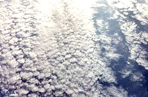
Altocumulus cloud as seen from the space shuttle. Altocumulus is formed through convective activity.

Convection cells on the Sun with North America superimposed
A convection cell is a phenomenon of fluid dynamics which occurs in situations where there are temperature differences within a body of liquid or gas.
Fluids are materials which exhibit the property of flow. Both gases and liquids have fluid properties, and, in sufficient quantity, even particulate solids such as salt, grain, or gravel show some fluid properties. When a volume of fluid is heated, it expands and becomes less dense, and thus more buoyant than the surrounding fluid. The colder, more dense fluid settles underneath the warmer, less dense fluid and forces it to rise. Such movement is called convection, and the moving body of liquid is referred to as a convection cell.
A rising body of fluid typically loses heat because it encounters a cold surface, because it exchanges heat with colder liquid through direct exchange, or in the example of the earth's atmosphere, because it radiates heat. At some point the fluid becomes more dense than the fluid underneath it, which is still rising. Since it cannot descend through the rising fluid, it moves to one side. At some distance its downward force overcomes the rising force beneath it and the fluid begins to descend. As it descends, it warms again through surface contact, conductivity, or compression, and the cycle repeats itself. (The heating through compression of descending air is what is responsible for such welcome winter phenomena as what is known in Western North America as a chinook or in the Alps as a foehn.)
Convection cells can form in any fluid, including the Earth's atmosphere, boiling water or soup (where the cells can be identified by particles they transport, such as grains of rice), the ocean, the surface of the sun, or even a farmer's field, where large rocks have been seen to be forced to the surface over time in a process either analogous to or directly related to convection (the connection is not yet clear).
The size of convection cells are largely determined by the fluid's properties, and they can even occur when the heating of a fluid is uniform.
The Sun's photosphere is composed of convection cells called granules, rising columns of superheated (5800 °C) plasma averaging about 1000 kilometres in diameter. The plasma cools as it rises and descends in the narrow spaces between the granules.
External links


