Difference between revisions of "AY Honors/Forestry/Answer Key"
m (222 revisions from w:Inclinometer: for use in AY Honor Forestry) |
|||
| Line 1: | Line 1: | ||
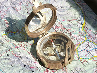
| − | + | [[Image:Stanley compass 1.jpg|thumb|Compass with inclinometer]] | |
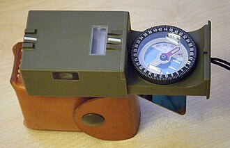
| − | + | [[Image:Sitometer Kern 2.jpg|thumb|Military model]] | |
| − | + | An '''inclinometer''' or '''clinometer''' is an instrument for measuring angles of [[slope]] (or tilt), [[elevation]] or [[depression (mood)|depression]] of an object with respect to gravity. It is also known as a ''tilt meter'', ''tilt indicator'', ''slope alert'', ''slope gauge'', ''gradient meter'', ''gradiometer'', ''level gauge'', ''level meter'', ''declinometer'', and ''pitch & roll indicator''. | |
| + | Clinometers measure both inclines (positive slopes, as seen by an observer looking upwards) and declines (negative slopes, as seen by an observer looking downward). [[Astrolabes]] are inclinometers that were used for navigation and locating astronomical objects. | ||
| − | + | In aircraft, the "ball" in [[turn coordinator]]s or [[turn and bank indicator]]s is sometimes referred to as an inclinometer. | |
| − | |||
| − | + | ==History== | |
| + | Early inclinometers include examples such as [[Well's inclinometer]], the essential parts of which are a flat side, or base, on which it stands, and a hollow disk just half filled with some heavy liquid. The glass face of the disk is surrounded by a graduated scale that marks the angle at which the surface of the liquid stands, with reference to the flat base. The line 0.—0. being parallel to the base, when the liquid stands on that line, the flat side is horizontal; the line 90.—90. being perpendicular to the base, when the liquid stands on that line, the flat side is perpendicular or plumb. Intervening angles are marked, and, with the aid of simple [[conversion tables]], the instrument indicates the rate of fall per set distance of horizontal measurement, and set distance of the sloping line. | ||
| − | + | One of the more famous inclinometer installations was on the panel of the Ryan NYP "The Spirit of St. Louis" - in 1927 Charles Lindbergh chose the lightweight [http://www.riekerinc.com/M-Inclinometer/ryan_nyp_spirit_of_st.htm Rieker Inc P-1057 Degree Inclinometer] to give him climb and descent angle information. | |
| − | + | ==Accuracy== | |
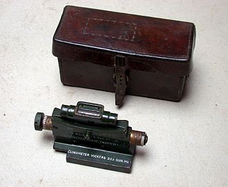
| + | [[File:Vickers Clino R.JPG|thumb|Clinometer designed to enable [[indirect fire]] capability with a [[Vickers machine gun]] circa 1918]] | ||
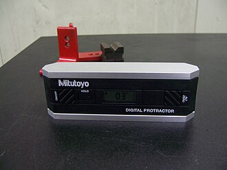
| + | [[File:Digital protractor.jpg|thumb|Digital protractor ]] | ||
| + | [[Image:Well's Clinometer - Project Gutenberg eText 19465.png|thumb|The Well's clinometer]] | ||
| + | [[Image:Clinometerlow.jpg|thumb|upright|Simple clinometer]] | ||
| + | Certain highly sensitive electronic inclinometer sensors can achieve an output resolution to 0.0001 degrees - depending on the technology and angle range, it may be limited to 0.01º. An inclinometer sensor's true or absolute accuracy (which is the combined total error), however, is a combination of initial sets of sensor zero offset and sensitivity, sensor linearity, hysteresis, repeatability, and the temperature drifts of zero and sensitivity - electronic inclinometers accuracy can typically range from .01º to ±2º depending on the sensor and situation. Typically in room ambient conditions the accuracy is limited to the sensor linearity specification. | ||
| − | + | ==Sensor technology== | |
| − | + | [[Tilt sensor]]s and inclinometers generate an [[artificial horizon]] and measure angular tilt with respect to this horizon. They are used in cameras, aircraft flight controls, automobile security systems, and speciality switches and are also used for platform leveling, boom angle indication, indeed anywhere tilt requires measuring. | |
| − | |||
| − | |||
| − | + | Important specifications to consider when searching for tilt sensors and inclinometers are the tilt angle range and number of axes (which are usually, but not always, [[orthogonal]]). The tilt angle range is the range of desired linear output. <!-- doesn't matter what it's measured in, and last sentence just repeats the back end of the first --> | |
| − | |||
| − | |||
| − | + | Common sensor technologies for tilt sensors and inclinometers are accelerometer, [[Liquid capacitive inclinometers|Liquid Capacitive]], electrolytic, gas bubble in liquid, and pendulum. | |
| − | == | + | |
| − | + | Tilt sensor technology has also been implemented in video games. ''[[Yoshi's Universal Gravitation]]'' and ''[[Kirby Tilt 'n' Tumble]]'' are both built around a tilt sensor mechanism, which is built into the cartridge. The [[PlayStation 3]] and [[Wii]] game controllers also use tilt as a means to play video games. | |
| − | + | ||
| − | + | Inclinometers are also used in [[civil engineering]], for example to measure the inclination of land to be built upon. | |
| − | + | ||
| − | + | Some inclinometers provide an electronic interface based on [[Controller_area_network|CAN (Controller Area Network)]]. In addition, those inclinometers may support the standardized [[Canopen|CANopen]] profile (CiA 410). In this case, these inclinometers are compatible and partly interchangeable. | |
| − | == | + | |
| + | ==Uses== | ||
| + | Inclinometers are used for: | ||
| + | * Determining latitude using [[Polaris]] (in the Northern Hemisphere) or the two stars of the constellation [[Crux]] (in the Southern Hemisphere). | ||
| + | * Determining the angle of the Earth's magnetic field with respect to the horizontal plane. | ||
| + | * Showing a deviation from the true vertical or horizontal. | ||
| + | * [[Surveying]], to measure an angle of inclination or elevation. | ||
| + | * Alerting an equipment operator that it may tip over.[http://www.riekerinc.com/TiltIndicators.htm] | ||
| + | * Measuring angles of elevation, slope, or incline, e.g. of an embankment. | ||
| + | * Measuring slight differences in slopes, particularly for [[geophysics]]. Such inclinometers are, for instance, used for monitoring [[volcano]]es, or for measuring the depth and rate of landslide movement. | ||
| + | * Measuring movements in walls or the ground in civil engineering projects.[http://www.slopeindicator.com/instruments/inclin-intro.html] | ||
| + | * Determining the [[Strike and dip|dip of beds]] or strata, or the slope of an embankment or cutting; a kind of plumb level. | ||
| + | * Some automotive [[safety]] systems. | ||
| + | * Indicating pitch and roll of vehicles, nautical craft, and aircraft. See [[turn coordinator]] and [[slip indicator]].[http://www.riekerinc.com/SlipIndicators.htm] | ||
| + | * Monitoring the boom angle of cranes and material handlers. | ||
| + | * Measuring the "look angle" of a satellite antenna towards a satellite. | ||
| + | * Adjusting a [[solar panel]] to the optimal angle to maximize its output. | ||
| + | * Measuring the slope angle of a tape or chain during distance measurement. | ||
| + | * Measuring the height of a building, tree, or other feature using a vertical angle and a distance (determined by taping or pacing), using [[trigonometry]]. | ||
| + | * Measuring the angle of drilling in [[well logging]]. | ||
| + | * Measuring the [[List (watercraft)|list]] of a [[ship]] in still water and the roll in rough water. | ||
| + | * Measuring steepness of a [[ski slope]]. | ||
| + | * Measuring the orientation of [[plane (mathematics)|plane]]s and [[lineation]]s in rocks, in combination with a [[compass]], in [[structural geology]]. | ||
| + | * Measuring [[Range of Motion]] in the joints of the body | ||
| + | * Measuring the inclination angle of the [[human pelvis|pelvis]]. | ||
| + | * Measuring the angles of elevation to, and ultimately computing the altitudes of, many things otherwise inaccessible for direct measurement.<!-- POV: This is especially useful in a classroom setting with children who will learn a valuable skill that applies directly to many careers. --> | ||
| + | |||
| + | == See also == | ||
| + | * [[Theodolite]] | ||
| + | * [[Clinometer (forestry)]] | ||
| + | * [[Tiltmeter]] | ||
| + | * [[Liquid capacitive inclinometers]] | ||
| + | |||
| + | == External links == | ||
| + | *[http://www.inclinometer.blogspot.com Inclinometer Blog - General Inclinometer Information] | ||
| + | |||
| + | [[Category:Surveying instruments]] | ||
| + | [[Category:Dimensional instruments]] | ||
| + | [[Category:Inclinometers]] | ||
| + | [[Category:Measuring instruments]] | ||
| + | |||
| + | [[ar:مميال]] | ||
| + | [[ca:Clinòmetre]] | ||
| + | [[da:Inklinometer]] | ||
| + | [[de:Neigungsmesser]] | ||
| + | [[et:Inklinomeeter]] | ||
| + | [[es:Clinómetro]] | ||
| + | [[fa:شیبسنج]] | ||
| + | [[fr:Inclinomètre]] | ||
| + | [[hi:नतिमापी]] | ||
| + | [[io:Klinometro]] | ||
| + | [[id:Inklinometer]] | ||
| + | [[it:Clinometro]] | ||
| + | [[nl:Hoekmeter]] | ||
| + | [[ja:クリノメーター]] | ||
| + | [[no:Klinometer]] | ||
| + | [[pl:Inklinometr]] | ||
| + | [[pt:Inclinômetro]] | ||
| + | [[ru:Инклинометр]] | ||
| + | [[sl:Klinometer]] | ||
| + | [[sv:Inklinometer]] | ||
| + | [[uk:Екліметр]] | ||
Revision as of 00:43, 20 November 2011
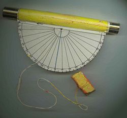
An inclinometer or clinometer is an instrument for measuring angles of slope (or tilt), elevation or depression of an object with respect to gravity. It is also known as a tilt meter, tilt indicator, slope alert, slope gauge, gradient meter, gradiometer, level gauge, level meter, declinometer, and pitch & roll indicator. Clinometers measure both inclines (positive slopes, as seen by an observer looking upwards) and declines (negative slopes, as seen by an observer looking downward). Astrolabes are inclinometers that were used for navigation and locating astronomical objects.
In aircraft, the "ball" in turn coordinators or turn and bank indicators is sometimes referred to as an inclinometer.
History
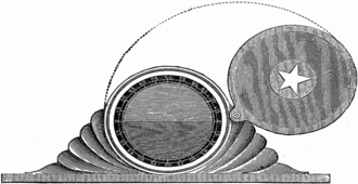
Early inclinometers include examples such as Well's inclinometer, the essential parts of which are a flat side, or base, on which it stands, and a hollow disk just half filled with some heavy liquid. The glass face of the disk is surrounded by a graduated scale that marks the angle at which the surface of the liquid stands, with reference to the flat base. The line 0.—0. being parallel to the base, when the liquid stands on that line, the flat side is horizontal; the line 90.—90. being perpendicular to the base, when the liquid stands on that line, the flat side is perpendicular or plumb. Intervening angles are marked, and, with the aid of simple conversion tables, the instrument indicates the rate of fall per set distance of horizontal measurement, and set distance of the sloping line.
One of the more famous inclinometer installations was on the panel of the Ryan NYP "The Spirit of St. Louis" - in 1927 Charles Lindbergh chose the lightweight Rieker Inc P-1057 Degree Inclinometer to give him climb and descent angle information.
Accuracy
Certain highly sensitive electronic inclinometer sensors can achieve an output resolution to 0.0001 degrees - depending on the technology and angle range, it may be limited to 0.01º. An inclinometer sensor's true or absolute accuracy (which is the combined total error), however, is a combination of initial sets of sensor zero offset and sensitivity, sensor linearity, hysteresis, repeatability, and the temperature drifts of zero and sensitivity - electronic inclinometers accuracy can typically range from .01º to ±2º depending on the sensor and situation. Typically in room ambient conditions the accuracy is limited to the sensor linearity specification.
Sensor technology
Tilt sensors and inclinometers generate an artificial horizon and measure angular tilt with respect to this horizon. They are used in cameras, aircraft flight controls, automobile security systems, and speciality switches and are also used for platform leveling, boom angle indication, indeed anywhere tilt requires measuring.
Important specifications to consider when searching for tilt sensors and inclinometers are the tilt angle range and number of axes (which are usually, but not always, orthogonal). The tilt angle range is the range of desired linear output.
Common sensor technologies for tilt sensors and inclinometers are accelerometer, Liquid Capacitive, electrolytic, gas bubble in liquid, and pendulum.
Tilt sensor technology has also been implemented in video games. Yoshi's Universal Gravitation and Kirby Tilt 'n' Tumble are both built around a tilt sensor mechanism, which is built into the cartridge. The PlayStation 3 and Wii game controllers also use tilt as a means to play video games.
Inclinometers are also used in civil engineering, for example to measure the inclination of land to be built upon.
Some inclinometers provide an electronic interface based on CAN (Controller Area Network). In addition, those inclinometers may support the standardized CANopen profile (CiA 410). In this case, these inclinometers are compatible and partly interchangeable.
Uses
Inclinometers are used for:
- Determining latitude using Polaris (in the Northern Hemisphere) or the two stars of the constellation Crux (in the Southern Hemisphere).
- Determining the angle of the Earth's magnetic field with respect to the horizontal plane.
- Showing a deviation from the true vertical or horizontal.
- Surveying, to measure an angle of inclination or elevation.
- Alerting an equipment operator that it may tip over.[1]
- Measuring angles of elevation, slope, or incline, e.g. of an embankment.
- Measuring slight differences in slopes, particularly for geophysics. Such inclinometers are, for instance, used for monitoring volcanoes, or for measuring the depth and rate of landslide movement.
- Measuring movements in walls or the ground in civil engineering projects.[2]
- Determining the dip of beds or strata, or the slope of an embankment or cutting; a kind of plumb level.
- Some automotive safety systems.
- Indicating pitch and roll of vehicles, nautical craft, and aircraft. See turn coordinator and slip indicator.[3]
- Monitoring the boom angle of cranes and material handlers.
- Measuring the "look angle" of a satellite antenna towards a satellite.
- Adjusting a solar panel to the optimal angle to maximize its output.
- Measuring the slope angle of a tape or chain during distance measurement.
- Measuring the height of a building, tree, or other feature using a vertical angle and a distance (determined by taping or pacing), using trigonometry.
- Measuring the angle of drilling in well logging.
- Measuring the list of a ship in still water and the roll in rough water.
- Measuring steepness of a ski slope.
- Measuring the orientation of planes and lineations in rocks, in combination with a compass, in structural geology.
- Measuring Range of Motion in the joints of the body
- Measuring the inclination angle of the pelvis.
- Measuring the angles of elevation to, and ultimately computing the altitudes of, many things otherwise inaccessible for direct measurement.
See also
External links
ar:مميال ca:Clinòmetre da:Inklinometer de:Neigungsmesser et:Inklinomeeter es:Clinómetro fa:شیبسنج fr:Inclinomètre hi:नतिमापी io:Klinometro id:Inklinometer it:Clinometro nl:Hoekmeter ja:クリノメーター no:Klinometer pl:Inklinometr pt:Inclinômetro ru:Инклинометр sl:Klinometer sv:Inklinometer uk:Екліметр
