Difference between revisions of "AY Honors/Weather/Answer Key"
| Line 34: | Line 34: | ||
==2. Identify either in the sky or from pictures the following types of clouds: cirrus, cumulus, stratus, nimbus. What kind of weather is associated with each.== | ==2. Identify either in the sky or from pictures the following types of clouds: cirrus, cumulus, stratus, nimbus. What kind of weather is associated with each.== | ||
| − | + | <gallery> | |
| + | Image:Cirrus over Warsaw, June 26, 2005.jpg|Cirrus | ||
| + | Image:Cumulus clouds in fair weather.jpeg|Cumulus | ||
| + | Image:St1.jpg|Stratus | ||
| + | Image:Rolling-thunder-cloud.jpg|Nimbus | ||
| + | </gallery> | ||
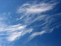
| + | ;Cirrus: Cirrus clouds are at the highest altitudes. They often appear thin and wispy. They are associated with fair weather. | ||
| + | |||
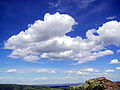
| + | ;Cumulus: Cumulus clouds are usually puffy and often have very distinct edges and usually a noticeable vertical development. They often have a popcorn-like appearance. Cells can be rather isolated or they can be grouped together in clusters. The first rain to fall out of the base of a cumulus cloud evaporates into the air beneath, cooling the air - often by several degrees. This cooled air descends, and the more it is cooled the more rapidly it descends. Thus instead of air rising into a cloud we have not only rain falling out the cloud, but air as well. This is why cool and rainy weather is assocaited with cirrus clouds. | ||
| + | |||
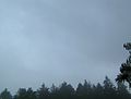
| + | ;Stratus: Stratus clouds belong to a class characterized by horizontal layering with a uniform base, as opposed to convective clouds that are as tall or taller than wide (these are termed cumulus clouds). More specifically, the term stratus is used to describe flat, featureless clouds of low altitude varying in color from dark gray to nearly white. These clouds are essentially fog that is above ground level and are formed either through the lifting of morning fog or when cold air moves at low altitudes over a region. These clouds do not usually bring precipitation, although if sufficiently low in altitude to become fog, drizzle or mist may result. | ||
| + | |||
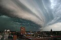
| + | ;Nimbus: Nimbus clouds are dark, precipituous clouds. Nimbus is a Latin word meaning cloud or rain storm. These are commonly called "thunderclouds." | ||
| + | |||
==3. Explain the action of a mercury or spirit thermometer, a mercury barometer, an aneroid barometer, and a rain gauge.== | ==3. Explain the action of a mercury or spirit thermometer, a mercury barometer, an aneroid barometer, and a rain gauge.== | ||
Revision as of 21:34, 30 December 2006
1. Explain how each of the following is formed:
a. Fog

Relative humidity is a measure of how much water is in the air compared to how much water can be in the air. As the temperature rises, the air can hold more water, and as it drops, it can hold less. When the humidity is 100% and the temperature drops, the air can no longer hold all the water that is in it. Fog is moisture that gets squeezed out of the air when the temperature drops.
b. Rain

Rain forms when separate drops of water fall to the Earth's surface from clouds
c. Dew

Dew is water in the form of droplets that appears on thin, exposed objects in the morning or evening. As the exposed surface cools by radiating its heat to the sky, atmospheric moisture condenses at a rate greater than that of which it can evaporate, resulting in the formation of water droplets.
d. Snow

Snow is precipitation in the form of crystalline water ice, consisting of a multitude of snowflakes. Since it is composed of small rough particles it is a granular material. It has an open and therefore soft structure, unless packed by external pressure.
Snow is commonly formed when water vapor undergoes deposition high in the atmosphere at a temperature of less than 0°C (32°F). It can also be produced by falling particles of ice fog formed when the humidity in surface air freezes at very low temperatures.
e. Sleet
In Britain and other Commonwealth countries, sleet refers to snow that has partially melted on its fall to the ground, due to surrounding air that is sufficiently warm to partially melt it while falling, but not warm enough to fully melt it into rain. Thus it refers to partially melted droplets, a mixture of snow and rain. It does not tend to form a layer on the ground, unless the ground has a temperature that is below freezing, when it can form a dangerous layer of invisible ice on surfaces known as 'black ice'.
In American usage, sleet is a form of precipitation consisting of tiny frozen raindrops, or ice pellets. This is often mistaken for hail, but forms in a different fashion and is usually (but not always) smaller. This occurs when snow flakes falling through a small layer of warmer air in the atmosphere will begin to melt. They can then refreeze if they pass back into a layer of colder, sub-freezing air closer to the ground, resulting in little balls of ice. These ice balls may bounce when they hit the ground, and do not freeze into a solid mass unless mixed with freezing rain.
f. Hail

Hail forms on condensation nuclei such as dust, insects, or ice crystals, when supercooled water freezes on contact. Hailstones are usually from the size of a pea to the size of a golfball.
g. Frost

If solid surfaces in contact with the air are chilled below the frost point, then structures of ice grow out from the solid surface. The size of the crystals depends on time and the amount of water vapor available.
2. Identify either in the sky or from pictures the following types of clouds: cirrus, cumulus, stratus, nimbus. What kind of weather is associated with each.
Cirrus
Cumulus
Stratus
Nimbus


- Cirrus
- Cirrus clouds are at the highest altitudes. They often appear thin and wispy. They are associated with fair weather.
- Cumulus
- Cumulus clouds are usually puffy and often have very distinct edges and usually a noticeable vertical development. They often have a popcorn-like appearance. Cells can be rather isolated or they can be grouped together in clusters. The first rain to fall out of the base of a cumulus cloud evaporates into the air beneath, cooling the air - often by several degrees. This cooled air descends, and the more it is cooled the more rapidly it descends. Thus instead of air rising into a cloud we have not only rain falling out the cloud, but air as well. This is why cool and rainy weather is assocaited with cirrus clouds.
- Stratus
- Stratus clouds belong to a class characterized by horizontal layering with a uniform base, as opposed to convective clouds that are as tall or taller than wide (these are termed cumulus clouds). More specifically, the term stratus is used to describe flat, featureless clouds of low altitude varying in color from dark gray to nearly white. These clouds are essentially fog that is above ground level and are formed either through the lifting of morning fog or when cold air moves at low altitudes over a region. These clouds do not usually bring precipitation, although if sufficiently low in altitude to become fog, drizzle or mist may result.
- Nimbus
- Nimbus clouds are dark, precipituous clouds. Nimbus is a Latin word meaning cloud or rain storm. These are commonly called "thunderclouds."
3. Explain the action of a mercury or spirit thermometer, a mercury barometer, an aneroid barometer, and a rain gauge.
4. Why is it possible to be rainy on one side of the mountain range and dry on the other? Give an illustration for your country or region.
a. Why is it cooler and more moist in the mountains than in the lowlands?
b. From which direction do rain and clear weather usually come in your locality?
5. Show with the help of a diagram how the earth's relationship to the sun produces the seasons.
6. What causes lightning and thunder? What different kinds of lightning are there?
7. Show with the help of a diagram what a convection is. What is its relation to winds?
8. Explain how radar, satellites, and computers are used in weather forecasting.
9. Tell how the following can affect our weather:
a. Jet stream

Jet streams are fast flowing, relatively narrow air currents found in the atmosphere at around 11 kilometres (36,000 ft) above the surface of the Earth. They form at the boundaries of adjacent air masses with significant differences in temperature, such as of the polar region and the warmer air to the south. For this reason, areas between the pole and the jet stream are cold, and area between the equator and the jet stream are warm. As the jet stream shifts along the north-south direction, the weather shifts as well.
Meteorologists now understand that the path of the jet stream steers cyclonic storm systems at lower levels in the atmosphere, and so knowledge of their course has become an important part of weather forecasting. Jet streams also play an important part in the creation of super cells, the storm systems which create tornados.
b. Volcano eruption
When a volcano erupts, it sends incredible amounts of volcanic ash into the atmosphere. This is enough to decrease the amount of sunlight that reaches the earth, causing a temporary (though sometimes devastating) global cooling. It also affects the intensity of the colors in the sunset for years.
10. Make a drawing showing the water cycle in weather.

The water cycle is the continuous movement of water over, above, and beneath the Earth's surface. It is powered by solar energy, and because it is a cycle, there is no beginning or end. As water moves around in the hydrosphere, it changes state among liquid, vapour, and ice. The time taken for water to move from one place to another varies from seconds to thousands of years, and the amount of water stored in different parts of the hydrosphere ranges up to 1.37 billion km³, which is contained in the oceans. Despite continual movement within the hydrosphere, the total amount of water at any one time remains essentially constant.
