Difference between revisions of "AY Honors/Weather/Answer Key/es"
(Created page with "</noinclude> <!-- 4. ¿Por qué es posible estar lluvioso de un lado de la cordillera y seco del otro? Dar un ejemplo de su país o región. ¿Por qué es más fresco y más h...") |
(Created page with "Precipitación inducida por humedad de relieve ocurre en muchos lugares alrededor del mundo. Los ejemplos incluyen: * Las costas orientales de Australia, donde prevalecen vien...") |
||
| Line 128: | Line 128: | ||
Las nubes orográficas ocurren cuando una masa de aire es forzada desde una zona baja hacia otra elevación más alta, ganando terreno. Mientras la masa de aire asciende en altitud se expande y enfría adiabáticamente. Esta atmósfera enfriada no puede mantener la humedad como lo haría más caliente, entonces eso efectivamente sube la humedad relativa a 100 %, creando nubes y frecuentemente llueve. | Las nubes orográficas ocurren cuando una masa de aire es forzada desde una zona baja hacia otra elevación más alta, ganando terreno. Mientras la masa de aire asciende en altitud se expande y enfría adiabáticamente. Esta atmósfera enfriada no puede mantener la humedad como lo haría más caliente, entonces eso efectivamente sube la humedad relativa a 100 %, creando nubes y frecuentemente llueve. | ||
| − | + | Precipitación inducida por humedad de relieve ocurre en muchos lugares alrededor del mundo. Los ejemplos incluyen: | |
| − | * | + | * Las costas orientales de Australia, donde prevalecen vientos del oriente, |
| − | * | + | * Las montañas de Nueva Zelandia, con vientos prevaleciendo del oeste, del océano Pacífico. |
| − | * | + | * Los Andes del sur, con vientos del oeste, del océano Pacífico. |
| − | * | + | * El noroeste de EE. UU., Canadá (Oregón, Washington Columbia Británica) con vientos del norte del océano Pacífico. Los lugares costeros con montañas pueden tenert 2500 mm de precipitación por año. Esas localidades al lado de las montañas en el paso de los sistemas de tormentas, reciben la humedad como agua líquida o como nieve. |
<noinclude></noinclude> | <noinclude></noinclude> | ||
Revision as of 13:32, 1 March 2021
| Climatología | ||
|---|---|---|
| Asociación General
|
Destreza: 1 Año de introducción: 1944 |
 |
Requisitos
1
1a

La humedad relativa es una medida de la cantidad de agua que está en el aire en comparación con la cantidad de agua que puede estar en el aire. Mientras la temperatura sube, el aire puede contener más agua, y mientras cae, puede contener menos. Cuando la humedad es 100% y la temperatura baja, el aire ya no puede mantener toda el agua. La niebla es la humedad que se exprime del aire cuando la temperatura baja. Esta humedad, un banco de niebla, puede ser pensado como una nube a nivel del suelo.
1b

La lluvia se forma cuando gotas separadas de agua caen a la superficie de la tierra desde las nubes.
Para que la lluvia caiga, el aire húmedo necesita enfriarse, lo que resulta en la condensación del vapor. Esto se logra comúnmente por algo que hace que el aire ascienda. El aire sube debido a: colinas y montañas (elevación orográfica), irregularidades en la superficie de la tierra, causando turbulencia mecánica o por fricción, sistemas de presión de aire que chocan (como frentes fríos debilitando aire más caliente), la elevación del aire caliente (convección), sistemas de baja presión en que hay un área general de movimiento hacia arriba.
Si hay suficiente humedad y el aire se eleva lo suficiente para formar densas nubes, podría haber lluvia de cualquiera de estos.
1c

El rocío es el agua en forma de gotas que aparece en objetos delgados y expuestos por la mañana o por la noche. Como la superficie expuesta se enfría mediante la radiación de su calor hacia el cielo, la humedad atmosférica se condensa a una velocidad mayor que la de que se puede evaporar, lo que resulta en la formación de gotitas de agua.
1d

La nieve es la precipitación en forma de hielo de agua cristalina, que consiste en una multitud de copos de nieve. Puesto que se compone de pequeñas partículas ásperas, es un material granular. Tiene una estructura abierta y por lo tanto suave, a menos que se llena de presión externa.
La nieve se forma comúnmente cuando el vapor de agua se somete a deposición alta en la atmósfera a una temperatura menos que 0° C. También puede ser producido por la caída de partículas de niebla de hielo formado cuando la humedad en el aire superficie se congela a temperaturas muy bajas.
1e
En Gran Bretaña y otros países, el aguanieve se refiere a la nieve que se ha fundido parcialmente en su caída al suelo, debido al aire que es suficientemente caliente para fundirlo parcialmente mientras cae, pero no suficientemente caliente como para derretirlo totalmente en lluvia. Por lo tanto, se refiere a las gotitas fundidas parcialmente, una mezcla de nieve y lluvia. No tienden a formar una capa en el suelo, a menos que el suelo tiene una temperatura que está debajo de la congelación, cuando se puede formar una capa de hielo peligroso invisible en las superficies conocidas como el 'hielo negro'.
En el uso estadounidense, aguanieve es una forma de precipitación que consiste en diminutas gotas de agua congeladas, o bolitas de hielo. Esto muchas veces se confunde con el granizo pero se forma de una manera diferente y es usualmente (pero no siempre) más pequeño. Esto ocurre cuando los copos de nieve que caen a través de una pequeña capa de aire más caliente en la atmósfera comienzan a derretirse. Pueden volver a congelarse si pasan de nuevo por una capa de aire más frío, lo que resulta en pequeñas bolas de hielo. Estas bolas de hielo pueden rebotar cuando dan al suelo y no se congelan en una masa sólida a menos que se mezclan con lluvia congelante.
1f

El granizo se forma en los núcleos de condensación como el polvo, insectos o cristales de hielo, cuando agua súper enfriada se congela al contacto. Las piedras de granizo son generalmente desde el tamaño de un guisante hasta el tamaño de una pelota de golf.
1g

Si las superficies sólidas se enfrían al contacto con el aire por debajo del punto de congelación, entonces estructuras de hielo crecen hacia fuera de la superficie sólida. El tamaño de los cristales depende del tiempo y la cantidad de vapor de agua disponible.
2
Cirros
Cúmulos
Estratos
Nimbos


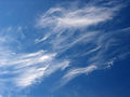
- Cirros
- Los cirros están en las altitudes más altas. Muchas veces aparecen delgados y ralos. Están asociados con el buen tiempo.
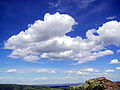
- Cúmulos
- Las nubes cúmulos son generalmente hinchadas y muchas veces tienen bordes muy distintas y usualmente un notable desarrollo vertical.Tienen generalmente una apariencia de palomitas de maíz. Las células pueden ser aislados o pueden agruparse. La primera lluvia que se cae de la base de un cúmulo se evapora en el aire por debajo, enfriando el aire - muchas veces por varios grados. Este aire enfriado desciende y cuanto más se enfría más rápidamente desciende. Así, en vez de aire subiendo a una nube, no sólo cae lluvia de la nube, sino también aire. Esta es la razón que el tiempo lluvioso y frío se asocia con nubes cúmulos.
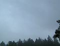
- Estratos
- Las nubes estratos pertenecen a una clase caracterizada por estratificación horizontal con una base uniforme, a diferencia de las nubes convectivas que son tan alto o más alto que ancho (estos se conocem como nubes cúmulos). Más específicamente, el término estratos se utiliza para describir las nubes planas, sin rasgos de baja altura que varían en color desde el gris oscuro a casi blanco. Estas nubes son esencialmente niebla que está por encima del nivel del suelo y se forman a través de la elevación de la niebla en la mañana o cuando se mueve el aire frío a bajas altitudes sobre una región. Estas nubes no suelen traer precipitaciones, aunque si están suficientemente bajas en altitud para convertirse en niebla, llovizna o neblina puede resultar.
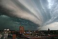
- Nimbos
- Las nubes nimbos son nubes escarpadas y oscuras. Nimbo es una palabra latina que significa nube o tormenta de lluvia. Estas son comúnmente llamadas «nubes de tormenta».
3
Termómetro de alcohol
Un termómetro de alcohol y un termómetro de mercurio funcionan con los mismos principios. Tanto el alcohol y el mercurio se expanden y contraen con los cambios de temperatura. Cuando hace frío, se contraen, y cuando hace calor, se expanden. Un termómetro puede ser construido para amplificar estas propiedades. Un tubo de vidrio con una bombilla en la parte inferior se llena con alcohol. El tubo permite un mayor volumen de alcohol y hay más para expandir. Cuando se expande, el único lugar que puede ir es en el tubo estrecho. La temperatura se lee dependiendo qué tan alto en el tubo la expansión lleva al alcohol.
Barómetro de Mercurio

Un barómetro de mercurio estándar tiene una columna de vidrio de 76 cm de altura, cerrado en un extremo, con un depósito abierto lleno de mercurio en su base. El mercurio en el tubo se ajusta hasta que el peso de la columna de mercurio equilibra la fuerza atmosférica ejercida en el depósito. Presión alta atmosférica pone más fuerza en contra del depósito, forzando el mercurio a subir en la columna. La baja presión permite que el mercurio caiga a un nivel más bajo en la columna mediante la reducción de la fuerza en contra del depósito.
Barómetro aneroide

El propósito de un barómetro es medir el peso de la atmósfera, o la presión ejercida por el aire. Un barómetro aneroide es similar a un globo en que tiene un recipiente lleno de aire. Cuando la presión de aire de afuera aumenta, también aumenta la presión de aire dentro del recipiente. La única manera en que puede hacerlo es mediante la disminución del volumen del recipiente - en otras palabras, la presión del aire exterior aplasta el recipiente. Volviendo a la analogía del globo, el globo sería más pequeño. Cuando la presión del aire exterior disminuye, el aire dentro del recipiente sigue disminuyendo en presión también. La única manera en que puede hacerlo es mediante la expansión, ocupando más volumen y haciendo que el recipiente sea más grande. En la analogía del globo, el globo se hace más grande. Un barómetro aneroide básicamente mide el grosor del recipiente.
Un barómetro aneroide utiliza una caja de metal pequeño y flexible llamado una célula aneroide. Esta cápsula (célula) aneroide está hecha de una aleación de berilio y cobre. La cápsula evacuada (o usualmente más cápsulas) se evita el colapso por un fuerte resorte. Pequeños cambios en la presión del aire exterior hacen la célula ampliarse o contraerse. Esta expansión y contracción impulsa palancas mecánicas tales que los pequeños movimientos de la cápsula se amplifican y aparecen en el frente del barómetro aneroide. Muchos modelos incluyen una aguja configurada manualmente que se utiliza para marcar la medición actual para que un cambio pueda ser visto. Además, el mecanismo se hace deliberadamente 'dura' de modo que al tocar el barómetro revela si la presión está aumentando o disminuyendo mientras el puntero se mueve.
Pluviómetro

El pluviómetro estándar consiste de un embudo unido a un cilindro que encaja en un recipiente más grande. Si el agua se desborda desde el cilindro, el recipiente exterior atrapará. Así que cuando se mide el cilindro se medirá y luego el exceso será puesto en otro cilindro y medido. En la mayoría de los casos, el cilindro está marcado en mm y en la imagen superior medirá hasta 25 mm de lluvia. Cada línea horizontal en el cilindro es de 0,2 mm. El recipiente más grande recopila la cantidad de lluvia más de 25 mm que fluye de un pequeño agujero en la parte superior del cilindro. Un tubo de metal está unido al recipiente y se puede ajustar para asegurar que el pluviómetro esté nivelado. Este tubo luego se coloca sobre una varilla de metal que se ha colocado en el suelo.
4

Las nubes orográficas ocurren cuando una masa de aire es forzada desde una zona baja hacia otra elevación más alta, ganando terreno. Mientras la masa de aire asciende en altitud se expande y enfría adiabáticamente. Esta atmósfera enfriada no puede mantener la humedad como lo haría más caliente, entonces eso efectivamente sube la humedad relativa a 100 %, creando nubes y frecuentemente llueve.
Precipitación inducida por humedad de relieve ocurre en muchos lugares alrededor del mundo. Los ejemplos incluyen:
- Las costas orientales de Australia, donde prevalecen vientos del oriente,
- Las montañas de Nueva Zelandia, con vientos prevaleciendo del oeste, del océano Pacífico.
- Los Andes del sur, con vientos del oeste, del océano Pacífico.
- El noroeste de EE. UU., Canadá (Oregón, Washington Columbia Británica) con vientos del norte del océano Pacífico. Los lugares costeros con montañas pueden tenert 2500 mm de precipitación por año. Esas localidades al lado de las montañas en el paso de los sistemas de tormentas, reciben la humedad como agua líquida o como nieve.
5

The Earth's tilt on its axis causes the seasons. When the axial tilt points a hemisphere away from the sun, it is winter, and when it points it towards the sun it is summer. This is not because the distance between that part of the Earth and the Sun varies, but rather, it is because the angle of the sunlight is either more direct, or less direct. The Earth's elliptical orbit about the sun causes its distance from the Sun to vary by a lot more than the axial tilt does, and it does not affect the seasons.
It is better to think of it this way: shine a flashlight on a piece of paper or cardboard. When the rays from the flashlight are parallel to the paper, the spot is circular. If you tilt the paper, the spot becomes elongated. The same amount of light strikes the paper in both cases, but the light is more concentrated in the circular spot verses the elongated spot. The area illuminated by the elongated spot is greater, so less light hits each square inch in the elongated "light spot". Less light means less heat, and in the case of the Earth, that means "winter".
6
Lightning
Lightning is caused when electrical charges build up in clouds. Scientists are still unsure exactly why that happens, but it is plausible that water droplets and ice travelling up and down within the cloud separate electrons from one another and transport them to the lower portions of the cloud. However this happens, it causes the cloud to have an electric field. When this field becomes strong enough, the electrons in the cloud begin to repel electrons on the ground, causing the ground to have a positive charge. When the voltage difference between the ground and the cloud becomes great enough, the air breaks down and actually conducts electricity. The air actually turns into plasma. When it conducts, the result is a lightning strike. The charge lowers toward earth usually splitting into filaments; these attract an upward plasma charge from objects on the earth such as trees, poles, towers, animals, blades of grass. These filaments are visible to the eye. Many of these charges will travel upwards but usually only one will contact the filaments in the air completing the circuit. Once this happens, lightning strikes with a gigantic release of energy.
Many people mistakenly believe that the reason a car is a good place to be during a lightning storm is because the rubber in the tires insulates the riders from the ground. But considering the fact that a lightning bolt may have just travelled a mile though the air, how much do you think a quarter inch of rubber is going to slow it down? Not at all! The reason you are safe in a car is because you are surrounded by a metal shell that will carry the electrical current around you instead of through you.
Thunder
Thunder is, even today, not completely understood by modern science. The word usually describes a sonic shock wave caused by the rapid heating and expansion of the air surrounding and within a bolt of lightning. The bolt changes the air into plasma and it instantly explodes, causing the sound known as a thunder clap.
This phenomenon occurs at the same time as a lightning flash, but a thunder clap is usually heard after lightning is seen because light travels faster (300,000,000 meters per second) than sound (around 300 meters per second). In very close proximity to the lighting strike, sound and light can be heard and seen almost simultaneously.
Kinds of Lightning
Some lightning strikes take on particular characteristics; scientists and the public have given names to these various types of lightning.
Intracloud lightning, sheet lightning, anvil crawlers
Intracloud lightning is the most common type of lightning, and occurs completely inside one cumulonimbus cloud; it is termed sheet lightning because the bolt is not seen, instead one sees the whole cloud light up from inside. Lightning that appears to travel extensively along the cloud anvil or its base is commonly called a crawler, or sometimes 'spider lightning'. Discharges of electricity in anvil crawlers travel up the sides of the cumulonimbus cloud branching out at the anvil top.
Cloud-to-ground lightning, anvil-to-ground lightning
Cloud-to-ground lightning is a great lightning discharge between a cumulonimbus cloud and the ground initiated by the downward-moving leader stroke. This is the second most common type of lightning. One special type of cloud-to-ground lightning is anvil-to-ground lightning, a form of positive lightning, since it emanates from the anvil top of a cumulonimbus cloud where the ice crystals are positively charged. In anvil-to-ground lightning, the leader stroke issues forth in a nearly horizontal direction until it veers toward the ground. These usually occur miles ahead of the main storm and will strike without warning on a sunny day. They are signs of an approaching storm and are known colloquially as "bolts out of the blue".
Cloud-to-cloud lightning
Cloud-to-cloud or intercloud lightning is a somewhat rare type of discharge lightning between two or more completely separate cumulonimbus clouds.
Ground-to-cloud lightning
Ground-to-cloud lightning is a lightning discharge between the ground and a cumulonimbus cloud from an upward-moving leader stroke. These thunderstorm clouds are formed wherever there is enough upward motion, instability in the vertical, and moisture to produce a deep cloud that reaches up to levels somewhat colder than freezing. These conditions are most often met in summer.
Heat lightning or summer lightning
Heat lightning (or, in the UK, "summer lightning") is nothing more than the faint flashes of lightning on the horizon or other clouds from distant thunderstorms. Heat lightning was named because it often occurs on hot summer nights. Heat lightning can be an early warning sign that thunderstorms are approaching. In Florida, heat lightning is often seen out over the water at night, the remnants of storms that formed during the day along a sea breeze front coming in from the opposite coast. In some cases, the thunderstorm may be too distant to hear the associated thunder from the lightning discharge.
Ball lightning
Ball lightning is described as a floating, illuminated ball that occurs during thunderstorms. They can be fast moving, slow moving or nearly stationary. Some make hissing or crackling noises or no noise at all. Some have been known to pass through windows and even dissipate with a bang. Ball lightning has been described by eyewitnesses but rarely, if ever, recorded by meteorologists.
7


A rising body of air typically loses heat because it radiates heat. At some point the air becomes denser than the air underneath it, which is still rising. Since it cannot descend through the rising air, it moves to one side. At some distance its downward force overcomes the rising force beneath it and the air begins to descend. As it descends, it warms again through surface contact, conductivity, or compression, and the cycle repeats itself. (The heating through compression of descending air is what is responsible for such welcome winter phenomena as what is known in Western North America as a Chinook wind or in the Alps as a Föhn wind.)
8
Radar
A weather radar is a type of radar used to locate precipitation, calculate its motion, estimate its type (rain, snow, hail, etc.), and forecast its future position and intensity. Modern weather radars are mostly doppler radars, capable of detecting the motion of rain droplets in addition to intensity of the precipitation. Both types of data can be analyzed to determine the structure of storms and their potential to cause severe weather.
Satellites
A weather satellite is a type of satellite that is primarily used to monitor the weather and climate of the Earth. These meteorological satellites, however, see more than clouds and cloud systems. City lights, fires, effects of pollution, auroras, sand and dust storms, snow cover, ice mapping, boundaries of ocean currents, energy flows, etc., are other environmental information collected from weather satellites.
El Niño and its effects on weather are monitored daily from satellite images. The Antarctic ozone hole is mapped from weather satellite data. Collectively, weather satellites flown by the U.S., Europe, India, China, Russia, and Japan provide nearly continuous observations for a global weather watch.
Visible-light images from weather satellites during local daylight hours are easy to interpret even by the average person; clouds, cloud systems such as fronts and tropical storms, lakes, forests, mountains, snow ice, fires, and pollution such as smoke, smog, dust and haze are readily apparent. Even wind can be determined by cloud patterns, alignments and movement from successive photos.
Computers
Computers are largely responsible for the accuracy of today's weather forecasts. Various computers are used not only to collect weather data from thousands of sensors around the world, but also for running weather simulations, and for presenting the information to the public on television news broadcasts.
Of these tasks, running weather simulations is certainly the most demanding. Numerical weather prediction models are computer simulations of the atmosphere. They take the analysis as the starting point and project the state of the atmosphere forward in time using an understanding of physics and fluid dynamics. The complicated equations which govern how the state of a fluid changes with time require supercomputers to solve them. The output from the model provides the basis of the weather forecast. There are a number of models that are used in forecasting, and each of them is a little different. Meteorologists look at the output of several and form their forecasts based on this.
9
9a

Jet streams are fast flowing, relatively narrow air currents found in the atmosphere at around 11 kilometers (36,000 ft) above the surface of the Earth. They form at the boundaries of adjacent air masses with significant differences in temperature, such as of the polar region and the warmer air to the south. For this reason, areas between the pole and the jet stream are cold, and area between the equator and the jet stream are warm. As the jet stream shifts along the north-south direction, the weather shifts as well.
Meteorologists now understand that the path of the jet stream steers cyclonic storm systems at lower levels in the atmosphere, and so knowledge of their course has become an important part of weather forecasting. Jet streams also play an important part in the creation of super cells, the storm systems which create tornadoes.
The jet stream, a narrow band of fast moving wind, generally above 9 km (30,000 feet) has three dimensional regions or pockets of maximum winds along the jet. Where the winds enter these max regions it is appropriately called an entrance region and where it exits, an exit region. As the wind accelerates going into a jet max it produces an area of divergence. This divergence aloft helps generate areas of convergence near the surface. These latter areas are called low pressure centers. And from them we get lots of weather. Besides helping to produce storm centers in the lower atmosphere, the jet stream then helps to steer these storms which are like pieces of wood caught in a fast moving stream of water.
9b
When a volcano erupts, it sends incredible amounts of volcanic ash into the atmosphere. This is enough to decrease the amount of sunlight that reaches the earth, causing a temporary (though sometimes devastating) global cooling. It also affects the intensity of the colors in the sunset for years.
The main effect on weather right near a volcano is that there is often a lot of rain, lightning, and thunder during an eruption. This is because all the ash particles that are thrown up into the atmosphere are good at attracting/collecting water droplets. We don’t quite know exactly how the lightning is caused but it probably involves the particles moving through the air and separating positively and negatively charged particles.
10

The water cycle is the continuous movement of water over, above, and beneath the Earth's surface. It is powered by solar energy, and because it is a cycle, there is no beginning or end. As water moves around in the hydrosphere, it changes state among liquid, vapour, and ice. The time taken for water to move from one place to another varies from seconds to thousands of years, and the amount of water stored in different parts of the hydrosphere ranges up to 1.37 billion km³, which is contained in the oceans. Despite continual movement within the hydrosphere, the total amount of water at any one time remains essentially constant.
11
Wind Vane
A simple wind vane can be made by fastening two sides of a strip of heavy paper around a short section of drinking straw. First, bend the strip in half. Place the straw in the bend and then glue the strip to itself. Drive a dowel, broom stick, or some similar item into the ground where you wish to measure the wind direction, and drive a finish nail into the top end. Then place the straw over the nail so that it may swing freely. When the wind blows, the vane (strip of paper and straw) will swivel on the nail indicating the wind direction.
Rain Gauge
A rain gauge is very simple to make. You will need a small, transparent vessel with constant diameter from top to bottom. If you have difficulty finding a vessel with constant diameter, you may opt to use a two-liter soda bottle. Strip off the label. Cut the top off the bottle, and fill it with plaster to a depth of 4 to 5 cm (this will provide a smooth bottom instead of the knobby bottom with which a two-liter bottle is typically endowed). You may wish to use epoxy instead of plaster - it is more expensive, but is more water proof. Plaster will work fine unless you plan to use the rain gauge for extended periods. You can also improve the water-resistance of the plaster by varnishing it.
Mark the sides of the vessel with a ruler, indicating millimeters and centimters, with the 0 mark coinciding with the bottom of the vessel's inside. Then set it outside where it can collect rain. When the rain ends, a quick comparison of the water level to the indicators will tell you how much rain fell. Empty the rain gauge between storms.
12
- a. La temperatura
- b. La humedad (rocío, niebla, lluvia, heladas o nieve)
- c. La formación de las nubes
- d. La dirección del viento
You may need to call your Pathfinders every day to get them to do this. It may help to build the weather instruments from requirement 11 first to build some excitement about weather. It may also help to work on this honor during the season in your area that has the most extreme weather. You can download a tracking chart here and give one to each of your students.
http://www.pathfindersonline.org/pdf/resources/weather_tracking_chart.pdf
This requirement is very similar to one found in the Explorer IA curriculum, except that Explorers are required to keep these records for 2 weeks instead of 1 week. Note that the month of record keeping neatly meets this requirement as well as the 3 weeks of record keeping required in the Weather-Advanced honor. Note that the Weather-Advanced Honor requires collecting additional types of data, so if you want to earn the Advanced honor collect all the data required from the beginning of your data collecting efforts and you will cover the basic requirements automatically.
If you forget to take records for a day, do not despair, just get the required number of days in total, even if they span more than a calender week or month.
If you are teaching this honor to a class of Explorers, there is a chart they can fill out in their diaries.
References
- http://science.howstuffworks.com/lightning.htm
- Wikipedia articles
- Categoría: Tiene imagen de insignia
- Adventist Youth Honors Answer Book/Honors/es
- Adventist Youth Honors Answer Book/es
- Adventist Youth Honors Answer Book/Skill Level 1/es
- Categoría: Libro de respuestas de especialidades JA/Especialidades introducidas en 1944
- Adventist Youth Honors Answer Book/General Conference/es
- Adventist Youth Honors Answer Book/Nature/es
- Adventist Youth Honors Answer Book/Nature/Primary/es
- Adventist Youth Honors Answer Book/Stage 100/es
- Adventist Youth Honors Answer Book
- Adventist Youth Honors Answer Book/Do at home
