Difference between revisions of "AY Honors/Oceans/Answer Key"
m (formatting) |
m |
||
| Line 51: | Line 51: | ||
</noinclude> | </noinclude> | ||
<!-- b. What is the salinity of the ocean? --> | <!-- b. What is the salinity of the ocean? --> | ||
| − | The salinity of the ocean is, on average, around 35 parts per thousand(ppt). This means that for every liter of water there are 35 grams of salt. | + | The salinity of the ocean is, on average, around 35 parts per thousand (ppt). This means that for every liter of water there are 35 grams of salt. |
<noinclude></translate></noinclude> | <noinclude></translate></noinclude> | ||
{{CloseReq}} <!-- 2b --> | {{CloseReq}} <!-- 2b --> | ||
Revision as of 00:35, 9 March 2022
1
1a
An ocean is a continuous body of saltwater covering a large portion of the Earth.
1b
Seas are much smaller and shallower than oceans. Seas are partially enclosed by the land of one or more continents and usually connected to an ocean.
1c
71%
2
2a
The concentration of salt in a given volume of water.
2b
The salinity of the ocean is, on average, around 35 parts per thousand (ppt). This means that for every liter of water there are 35 grams of salt.
2c
Add 35 grams (2½ tablespoons) of salt to a beaker or bowl. Next, add 1000 grams (4 cups) of water (preferably tap water) to the beaker or bowl. Stir the mixture until the salt is completely dissolved in the water. When the salt is completely dissolved in the water you have seawater.
Lesson plan from the Surfing Scientist
i
ii
3
The Pacific Ocean is the largest ocean (approx. 60 million square miles).
The Philippine Sea is the largest sea (approx. 2 million square miles).
4
4a
4b
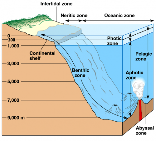
The photic zone is the uppermost layer of the ocean. Here the sun can penetrate, allowing photosynthesis to occur. The aphotic zone is below the photic zone and receives little to no sunlight.
5
5a
Wind is caused by air flowing from a high pressure to a lower pressure.
5b
The differences in temperature between the equator and the poles and the rotation of the earth. At the equator the sun warms the air more than any other place causing the air to rise and flow towards the poles. The colder, denser air moves towards the equator at the same time to replace the heated air.
5c
When the rotation of the earth causes the winds in the northern hemisphere to appear to be curving to the right and the winds in the southern hemisphere to appear to curve to the left.
5d
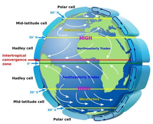
Polar Easterlies: Dry, cold winds that originate at the poles and flow to the subpolar regions where the pressure is lower.
Westerlies: Come from the west at midlatitudes and are sustained by polar easterlies. They are strongest in the winter when the pressure at the poles is low.
Trade Winds: Strong winds that blow east across the tropics. These winds are very predictable. Most tropical storms originate as a trade wind.
Doldrums: The place where the trade winds from both hemispheres meet (the intertropical convergence zone). The winds here are very weak to nonexistent and the weather is usually calm.
6
6a
Tides are caused by the gravitational pull of the moon, and to a lesser extent by the pull of the sun.
6b
- High tide and Low tide
The high tide occurs twice per day, as does the low tide. These tides are caused by the way the moon's gravity acts differently on the rigid parts of the earth as compared to how it acts on the oceans. Since the earth is rigid (except for the large bodies of water that experience tides), the pull of the moon's gravity acts on the entire planet evenly - as if all of the gravitational force were applied to the earth's center. Thus, the equations relating gravity's force to distance work as if the distance were from the center of the earth, not as if it were on any point on the surface. But the oceans are different. Since they are fluid, and not rigid, the moon's pull acts as though each molecule of water were independent. So gravity acts on the ocean relative to the distance between the moon and the earth's surface (where the oceans are) and not the distance between the moon and the center of the earth.
As the earth rotates, a given point on the earth (such as a seashore) gets nearer and nearer to the moon until it is as close to the moon as it will get on that day. When this happens, the gravitational pull on the ocean is at its greatest (since the force of gravity increases as distance decreases). Since the ocean is closer to the moon than the center of the earth, it pulls harder on the ocean, and this causes the ocean to rise up. That causes a high tide.
The earth continues to rotate, and our point on the seashore is soon getting farther and farther from the moon causing the tide to recede (i.e., we experience a low tide). When the earth rotates our seashore to 90 degrees relative to the moon the pull on the rigid earth is abut the same as it is on the center of the earth since the distances are about the same. But then as the earth continues to rotate a remarkable thing happens - the tide begins to rise again even though the seashore is getting farther from the moon. When it rotates to 180 degrees relative to the moon, the seashore is at its farthest distance from the moon on that day, and we get another high tide! How does this happen? Isn't the pull of the moon on the ocean at its weakest then? Yes, but the pull on the rigid parts of the plant is stronger than the pull on the ocean.
Therefore, when the ocean is on the opposite side of the earth relative to the moon, it is farther away, and the moon does indeed pull on it less than when the ocean is nearest the moon. But the moon is pulling at the rigid part of the earth's center which is closer to the moon, with the effect that the moon is pulling on the rigid portion with more force than it is pulling on the more distant ocean. In other words, we get a second high tide each day when the ocean is farthest from the moon because the moon is pulling the earth away from its ocean.
- Neap tides and Spring tides
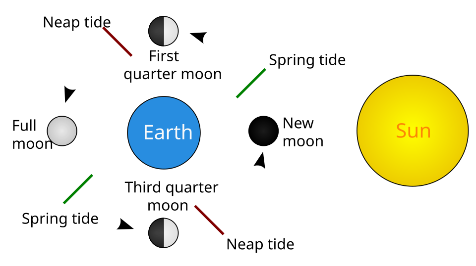
Neap and spring tides describe the difference between the low tide and the high tide. When the high tide is very high and the low tide is very low on the same day, we have a spring tide. When the high tide is less high and the low tide is less low, it's a neap tide. We get two neap tides and two spring tides each month, because they are influenced by the phase of the moon (which is controlled by the relative position of the earth, sun, and moon).
The sun affects the tides in the same way that the moon does, but the sun has a much lesser pull on the oceans than the moon does, because it is much farther away, and therefore the effect is much smaller. But it does have an effect, which is what accounts for the the neap and spring tides. When the sun and moon are 90 degrees apart, they do not work together to reinforce the tidal effect. One of them will be trying to cause a high tide, and the other will be trying to cause a low tide, so the high tide is not as high, and the low tide is not as low (a neap tide). When the sun, moon, and earth are in a straight line, they do work together to make the high tides higher, and the low tides lower, thus giving us the spring tide. Therefore, we get a spring tide when we have a new moon (when the moon and sun are both on the same side of the earth) and when we have a full moon (when the sun and moon are on opposite sides of the earth). The neap tides occur at the first quarter moon and three quarter moon.
6c
7
7a
Surface currents occur at 328 feet deep or above. They are driven primarily by winds. There are two different types of surface currents. These are coastal currents and surface ocean currents.
Coastal currents are divided into different types as well. Longshore currents, rip currents, upwelling and downwelling are all coastal currents because they are all driven by local or coastal winds and typically occur near the shoreline. Longshore currents occur when a wave hits the beach at an angle instead of head on. Part of the wave’s energy runs parallel to the shore creating the longshore current. Barrier Islands and land formations called spits are formed by these currents. Rip currents are caused when underwater land formations block the waves from flowing directly back to the ocean. When the waves that have already crashed flow through a narrow passage it creates a lot of force and creates a rip current. Upwelling and downwelling occur when the wind blows the surface water away causing the deeper water to replace it or the opposite when the wind blows the surface water towards a barrier and the force of the wind causes it to sink. These currents are important to the cycling of nutrients, oxygen, and other gasses in the ocean. Surface oceans currents are driven by global wind patterns.
7b
Deep ocean currents (the global conveyor belt) are driven by the density of the water. The more salt in the water the denser it becomes. When water freezes at the poles it leaves the salt behind creating a large amount of dense, cold water that eventually sinks allowing more water to replace it. This causes a current that eventually goes around the entire world.
These deep-water currents move a lot slower than surface currents, about a few centimeters per second. The deep-water currents distribute nutrients and help regulate temperatures. Some ocean animals use these currents to migrate.
7c
When the rotation of the earth causes the winds in the northern hemisphere to appear to be curving to the right and the winds in the southern hemisphere to appear to curve to the left.
7d
- i. Use a blue writing utensil to represent the cold dense currents.
- ii. Use a red writing utensil to represent the warm less dense currents.
- iii. Label the oceans that the global conveyor belt passes through.
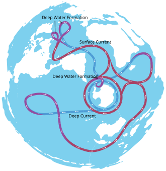
The current begins near the North Pole getting warmer as it travels south around South America eventually coming to Antarctica where it picks up cold water again. It then splits, one part traveling to the Indian Ocean and the other to the Pacific Ocean. As these currents reach the equator, they get warmer and eventually make their way back around South America and up in the North Atlantic Ocean where the cycle starts again. The water moves quite slowly at about 10 cm per second. It can take up to 1000 years for water in the North Atlantic to end up in the North Pacific!
7e
Materials Needed:
- Pyrex® baking dish, 2-qt. or 1.5-qt. in size.
- Alternatively, other similarly sized, heat-resistant glass baking ware that can safely withstand the hot temperatures of being placed just above a flame for several minutes could be used instead.
- Thyme, dried (2 tsp.)
- Alternatively, any other dried leaf spice could be used.
- Teaspoon
- Vegetable oil (about 4 cups)
- Measuring cup
- Spoon
- Ceramic coffee mugs (2). These should be equal in height.
- Small candles or cans of Sterno® (4). These should be much shorter than the coffee mugs so that the flame does not get too close to the bottom of the glass baking dish.
- Lighter or matches
- Thermometer
- Notebook/Pencil or Pen
Experiment:
- On a surface that is safe to spill some vegetable oil, fill the baking dish about half to three-quarters full of vegetable oil. (Depending on the exact size of baking dish you are using, this may be about 4 cups of vegetable oil or less.)
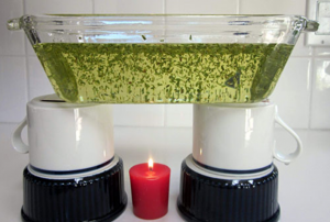
- Mix the 2 teaspoons of thyme in with the vegetable oil in the baking dish. Stir thoroughly to distribute the flakes of thyme. The flakes of thyme will flow with the liquid, showing the direction and velocity of any fluid flow.
- Place the baking dish on top of the two ceramic mugs.
- Observe the oil and spice mixture. With no heat (energy) being added to the system, there should be little or no movement of the liquid, once it has settled.
- Place a candle underneath the baking dish, directly in the middle. Make sure the mugs still stably support the baking dish.
- Light the candle and let the liquid heat up for at least one minute. Your setup should look like the picture below. You can also use a can of Sterno instead of a candle. Sterno cans produce more heat than candles do.
- As the oil heats and begins to flow, observe the pattern of fluid flow (circulation) by noting the location of individual flakes of thyme over time. Write down all of your observations in your lab notebook. This type of energy movement is called thermal convection, because added heat causes the fluid flow (circulation by convection) by lowering the density of the liquid.
- Be sure to view the model several times during the experiment, both from above the dish and from the side of the dish.
- Draw a sketch of the circulation in your lab notebook.
- Measure the temperature of the oil in different parts of the model.
- What is the biggest temperature difference you can find?
- Record the temperature in your notebook.
7f
Tidal currents are caused by tides. They are a horizontal movement that accompanies a rise and fall in the water level caused by a tide. The two different types of tidal currents are: flood current and ebb current.
Flood current: Occurs when the tide is rising, and the current is going towards the shore.
Ebb current: Occurs when the tide is falling, and the current is going to back towards the ocean.
7g
In the Atlantic Ocean there is a strong current called the Gulf Stream. The Gulf Stream carries warm water from the Gulf of Mexico to western Europe. This makes western Europe much warmer than other places at the same latitude.
8
Weather: The evaporation of ocean water causes an increase in humidity and temperature in the surrounding land. This evaporation leads to the making of clouds in the atmosphere which can bring rain and storms. These clouds can be blown long distances by winds (nearly all rain originates from the ocean).
Temperature: Most of the heat from the sun is stored in the ocean. The heat is then distributed around the earth helping to regulate the earth’s temperature.
Breathing: More than half of the oxygen we breathe comes from photo-synthesizers in the ocean such as algae, kelp, and phytoplankton.
9
9a
- Climate change/global warming
- Plastic pollution
- Overfishing
- Acidification
- Habitat destruction
9b
- Conserve water – less wastewater and runoff go into the ocean.
- Reduce pollutants – choose nontoxic chemicals and dispose of them properly
- Reduce waste – cut down on what you throw away by reusing and recycling
- Cut down on the amount of plastic you use and purchase – use reusable bags, water bottles etc.
- Use energy efficient light bulbs – using less electricity means less pollution
- Turn down your thermostat – the less fossil fuels and electricity used means less carbon in the air (extra carbon in the air traps too much heat causing greenhouse gas emissions)
- Fish responsibly – “catch and release,” only fish in areas where it is allowed, only catch what you need
- Practice safe boating – follow “no wake” zones, anchor your boat away from coral reefs and sea grasses
- Pick up trash around beaches and your community
- Reduce vehicle emissions – ride your bike, walk, carpool, use fuel efficient vehicles.
9c
10
Animal:
Plant:
Fungi:
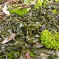
The shell of this sea snail, Littoraria irrorata, is covered with the lichen Pyrenocollema halodytes
Bacteria:
Archaea:
Algae:
11
11a
Some examples include: The crossing of the Red Sea (Exodus 14), Jonah and the Whale (Jonah 1-3), and Jesus calms the storm (Matthew 8, Mark 4, and Luke 8)
11b
11c
12
12a
12b
12c
12d
12e
